Category:Herrenbauernhaus Rütimatt
Jump to navigation
Jump to search
| Object location | | View all coordinates using: OpenStreetMap |
|---|
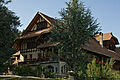
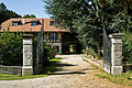
manorial farmhouse in Gerzensee in the canton of Bern, Switzerland  | |||||
| Upload media | |||||
| Instance of | |||||
|---|---|---|---|---|---|
| Part of | |||||
| Location | Gerzensee, Bern-Mittelland administrative district, Bernese Mittelland administrative region, Bern, Switzerland | ||||
| Street address |
| ||||
| Heritage designation | |||||
| Inception |
| ||||
 | |||||
Media in category "Herrenbauernhaus Rütimatt"
The following 5 files are in this category, out of 5 total.
-
 Gerzensee Herrenbauernhaus1.jpg 2,863 × 1,900; 5.56 MB
-
 Gerzensee Herrenbauernhaus2.jpg 3,026 × 2,011; 6.92 MB
-
 Gerzensee Herrenbauernhaus3.jpg 4,176 × 2,784; 8.59 MB
-
 Gerzensee Herrenbauernhaus4.jpg 2,967 × 1,978; 6.42 MB
-
 Gerzensee Herrenbauernhaus5.jpg 2,847 × 1,898; 5.35 MB


