Category:Herenstraat 10, Buren
Jump to navigation
Jump to search
| Object location | | View all coordinates using: OpenStreetMap |
|---|
 | |||||
| Upload media | |||||
| Instance of |
| ||||
|---|---|---|---|---|---|
| Location | Buren, Gelderland, Netherlands | ||||
| Street address |
| ||||
| Located on street |
| ||||
| Heritage designation |
| ||||
 | |||||
|
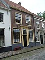
This is a category about rijksmonument number 11313
|
| Address |
|
Media in category "Herenstraat 10, Buren"
The following 7 files are in this category, out of 7 total.
-
 Exterieur VOORGEVELS - Buren - 20305681 - RCE.jpg 1,197 × 1,200; 351 KB
-
 Grote Kerkstraat - Buren - 20045657 - RCE.jpg 1,200 × 951; 273 KB
-
 Herenstraat 10 front.jpg 2,448 × 3,264; 3.35 MB
-
 Overzicht gevelwand - Buren - 20045634 - RCE.jpg 1,200 × 789; 204 KB
-
 Stairs with convex and concave steps - side view.jpg 2,448 × 3,264; 3.05 MB
-
 Stairs with convex and concave steps - top view.jpg 2,448 × 3,264; 3.48 MB
-
 Voordeur - Buren - 20045635 - RCE.jpg 893 × 1,200; 242 KB


