Category:Herengracht 63, Amsterdam
Jump to navigation
Jump to search
| Object location | | View all coordinates using: OpenStreetMap |
|---|
 | |||||
| Upload media | |||||
| Instance of |
| ||||
|---|---|---|---|---|---|
| Location | Amsterdam, North Holland, Netherlands | ||||
| Street address |
| ||||
| Located on street | |||||
| Heritage designation |
| ||||
 | |||||
|
This is a category about rijksmonument number 1531
|
| Address |
|
Media in category "Herengracht 63, Amsterdam"
The following 8 files are in this category, out of 8 total.
-
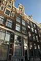 Amsterdam - Herengracht 63.JPG 3,056 × 4,592; 4.8 MB
-
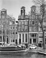 Exterieur VOORGEVELS, OVERZICHT - Amsterdam - 20298797 - RCE.jpg 959 × 1,200; 318 KB
-
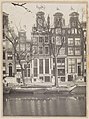
 Gevelaanzichten - Amsterdam - 20017162 - RCE.jpg 894 × 1,200; 300 KB
-
 Stadsarchief Amsterdam, Afb 012000006453.jpg 2,055 × 2,321; 690 KB
-
 Stadsarchief Amsterdam, Afb 012000006457.jpg 2,118 × 2,842; 936 KB
-
 Stadsarchief Amsterdam, Afb 012000006458.jpg 1,942 × 2,658; 786 KB
-
 Stadsarchief Amsterdam, Afb 012000006646.jpg 2,133 × 2,842; 916 KB
-
 Steenbergh, C.J. (1859-1939), Afb 012000009586.jpg 2,068 × 2,844; 1.22 MB


,_Afb_012000009586.jpg)