Category:Herdenkingsmonument IJsselstein
Jump to navigation
Jump to search
| Object location | | View all coordinates using: OpenStreetMap |
|---|
 | |||||
| Upload media | |||||
| Instance of | |||||
|---|---|---|---|---|---|
| Commemorates | |||||
| Made from material |
| ||||
| Genre | |||||
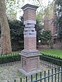
| Location | IJsselstein, Utrecht, Netherlands | ||||
| Street address |
| ||||
| Inception |
| ||||
| Date of official opening |
| ||||
 | |||||
Nederlands: Ontwerper van het monument: Jóska Tóth. Onthuld op 27 april 1995 in het Kronenburghplantsoen, Utrechtsestraat bij 9
BRON:Historische Kring IJsselstein, Van oorlogsmonument naar herdenkingsmonument pagina 297 t/m 314
|
This is a category about a war memorial in the Netherlands, number: 1697
|
Media in category "Herdenkingsmonument IJsselstein"
The following 7 files are in this category, out of 7 total.
-
 Detail Herdenkingsmonument Zuil 'Zij die Vielen'.jpg 2,560 × 1,920; 1.77 MB
-
 Herdenkingsmonument IJsselstein, detail 01.jpg 3,240 × 4,320; 4.08 MB
-
 Herdenkingsmonument IJsselstein, detail 02.jpg 3,240 × 4,320; 3.23 MB
-
 Herdenkingsmonument IJsselstein, detail 03.jpg 4,320 × 3,240; 2.52 MB
-
 Herdenkingsmonument IJsselstein, detail 04.jpg 4,320 × 3,240; 2.94 MB
-
 Herdenkingsmonument IJsselstein, detail 05.jpg 3,240 × 4,320; 4.44 MB
-
 Herdenkingsmonument Zuil 'Zij die Vielen'.jpg 1,920 × 2,560; 1.92 MB


