Category:Henschelstraße 11 (Frankfurt)
Jump to navigation
Jump to search
| Object location | | View all coordinates using: OpenStreetMap |
|---|
Media in category "Henschelstraße 11 (Frankfurt)"
The following 3 files are in this category, out of 3 total.
-
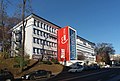
 Frankfurt, Henschelstraße 11, AWO (1).jpg 6,472 × 3,272; 13.34 MB
-
 Frankfurt, Henschelstraße 11, AWO (2).jpg 4,560 × 3,097; 11.41 MB
-
 Frankfurt, Henschelstraße 11, AWO.jpg 4,521 × 3,058; 11.89 MB
.jpg)
.jpg)
