Category:Hengkeng
Jump to navigation
Jump to search
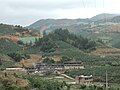
English: A small farm compound (not a classic tulou, but definitely built using the same techniques), labeled "Hengkeng" on Google Maps and Sogou Maps。 This Hengkeng is apparently merely a "natural village", a part of some larger "administrative village"
中文:横坑
| Object location | | View all coordinates using: OpenStreetMap |
|---|
Media in category "Hengkeng"
The following 4 files are in this category, out of 4 total.
-
 S309 - DSCF3990 - Hengkeng.JPG 2,848 × 2,136; 2.69 MB
-
 S309 - DSCF3991 - Hengkeng.JPG 2,048 × 1,536; 1.49 MB
-
 S309 - DSCF3992 - Hengkeng.JPG 2,048 × 1,536; 1.49 MB
-
 S309 - DSCF3993 - Hengkeng.JPG 2,848 × 2,136; 2.59 MB


