Category:Helsby Road bridge, Walton
Jump to navigation
Jump to search
| Object location | | View all coordinates using: OpenStreetMap |
|---|
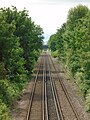
This bridge originally carried Church Avenue, which turned south at its end, across the railway and onto Bull Lane. Some time after 1890, Helsby Road was built and this bridge now serves as a footpath.
Media in category "Helsby Road bridge, Walton"
The following 4 files are in this category, out of 4 total.
-
 Helsby Road bridge 1.jpg 5,152 × 3,864; 7.26 MB
-
 Helsby Road bridge 2.jpg 5,152 × 3,864; 7.69 MB
-
 HTS & SJO2 Intersection bridge from Helsby Road bridge 1.jpg 5,152 × 3,864; 8.5 MB
-
 HTS & SJO2 Intersection bridge from Helsby Road bridge 2.jpg 3,864 × 5,152; 10.04 MB


