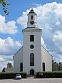
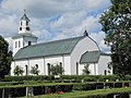
Category:Hedesunda kyrka
Jump to navigation
Jump to search
| Object location | | View all coordinates using: OpenStreetMap |
|---|
church building in Gävle Municipality, Sweden  | |||||
| Upload media | |||||
| Instance of | |||||
|---|---|---|---|---|---|
| Location | Gävle Municipality, Gävleborg County, Sweden | ||||
| Diocese | |||||
| Connects with |
| ||||
| Has use |
| ||||
| Occupant | |||||
| Heritage designation |
| ||||
| Date of official opening |
| ||||
 | |||||
Svenska: Hedesunda kyrka
|
This is a category about an ecclesiastical monument in Sweden, number 21300000004019 (sub-number: 21400000444569) in the RAÄ buildings database.
|
Subcategories
This category has the following 2 subcategories, out of 2 total.
I
- Interior of Hedesunda kyrka (144 F)
Media in category "Hedesunda kyrka"
The following 9 files are in this category, out of 9 total.
-
 Hedesunda kyrka - KMB - 16000200031511.jpg 463 × 600; 76 KB
-
 Hedesunda kyrka - KMB - 16000200031513.jpg 795 × 600; 118 KB
-
 Hedesunda kyrka - KMB - 16000200031514.jpg 790 × 600; 110 KB
-
 Hedesunda kyrka - KMB - 16000200031528.jpg 426 × 600; 60 KB
-
 Hedesunda kyrka - KMB - 16000200031532.jpg 434 × 600; 63 KB
-
 Hedesunda kyrka - KMB - 16001000065366.jpg 537 × 780; 74 KB
-
 Hedesunda kyrka ext1.jpg 3,000 × 4,000; 2.16 MB
-
 Hedesunda kyrka ext2.jpg 4,000 × 3,000; 3.41 MB
-
 Hedesunda kyrka ext3.jpg 3,000 × 4,000; 2.33 MB


