Category:Headlands of Northern Ireland
Jump to navigation
Jump to search
Wikimedia category | |||||
| Upload media | |||||
| Instance of | |||||
|---|---|---|---|---|---|
| Category combines topics | |||||
| |||||
Subcategories
This category has the following 2 subcategories, out of 2 total.
A
B
- Ballyquintin Point (8 F)
Media in category "Headlands of Northern Ireland"
The following 34 files are in this category, out of 34 total.
-
 Ballygally Head near Larne - geograph.org.uk - 324150.jpg 640 × 426; 132 KB
-
 Ballygally Head, Antrim coast road - geograph.org.uk - 212146.jpg 640 × 426; 130 KB
-
 Carrickarade Island - geograph.org.uk - 455697.jpg 640 × 480; 294 KB
-
 Derginan Point from West Lighthouse - geograph.org.uk - 646851.jpg 640 × 480; 84 KB
-
 Geo - geograph.org.uk - 475621.jpg 640 × 409; 250 KB
-
 Geo - geograph.org.uk - 475623.jpg 640 × 427; 253 KB
-
 Gobe Feagh or Ravens' Point - geograph.org.uk - 471766.jpg 640 × 427; 245 KB
-
 Headlands - geograph.org.uk - 471962.jpg 640 × 414; 251 KB
-
 Kinbane - geograph.org.uk - 471754.jpg 640 × 427; 289 KB
-
 Kinbane Head - geograph.org.uk - 471726.jpg 640 × 420; 247 KB
-
 Kinbane Head - geograph.org.uk - 471741.jpg 640 × 424; 283 KB
-
 Kinbane Head - geograph.org.uk - 471757.jpg 640 × 427; 284 KB
-
 Kinbane Head - geograph.org.uk - 471763.jpg 640 × 421; 280 KB
-
 Kinbane Head - geograph.org.uk - 471765.jpg 640 × 399; 244 KB
-
 Larry Bane Bay - geograph.org.uk - 28406.jpg 640 × 480; 85 KB
-
 Larry Bane Bay - geograph.org.uk - 394905.jpg 640 × 480; 113 KB
-
 Larry Bane Bay - geograph.org.uk - 472378.jpg 640 × 411; 272 KB
-
 Larry Bane Bay looking east - geograph.org.uk - 28409.jpg 640 × 480; 107 KB
-
 Over the sea to Skye^ - geograph.org.uk - 668916.jpg 640 × 480; 72 KB
-
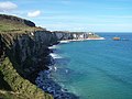
 Portaneevey cliffs - geograph.org.uk - 401997.jpg 480 × 640; 83 KB
-
 Rathlin Island - geograph.org.uk - 444011.jpg 640 × 424; 64 KB
-
 Ravens' Point or Gobe Feagh - geograph.org.uk - 471767.jpg 640 × 417; 252 KB
-
 Sea Stack - geograph.org.uk - 471901.jpg 482 × 640; 277 KB
-
 Sheep Island in Summer - geograph.org.uk - 555983.jpg 640 × 480; 73 KB
-
 The Cave Hill - geograph.org.uk - 449330.jpg 640 × 478; 69 KB
-
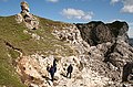
 The path to Kenbane Head near Ballycastle - geograph.org.uk - 425832.jpg 640 × 426; 169 KB
-
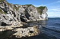
 White Cliffs - geograph.org.uk - 475594.jpg 640 × 330; 188 KB
-
 Benbane Head - geograph.org.uk - 475883.jpg 640 × 411; 244 KB
-
 Carrickarade - geograph.org.uk - 472412.jpg 640 × 406; 230 KB
-
 Glencloy Glen - geograph.org.uk - 641698.jpg 640 × 427; 43 KB
-
 Larry Bane Head - geograph.org.uk - 453955.jpg 640 × 423; 94 KB
-
 Rathlin Island - geograph.org.uk - 441842.jpg 640 × 424; 44 KB
-
 Rue Point, Rathlin Island, Co. Antrim - geograph.org.uk - 190384.jpg 640 × 483; 63 KB
-
 Sroanderrig Point - geograph.org.uk - 441941.jpg 640 × 424; 53 KB


