Category:Hazard maps of volcanoes
Jump to navigation
Jump to search
Subcategories
This category has the following 3 subcategories, out of 3 total.
V
Media in category "Hazard maps of volcanoes"
The following 14 files are in this category, out of 14 total.
-
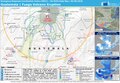
 ECDM 20180123 Philippines-PNG Volcanic eruptions.pdf 1,625 × 1,125; 712 KB
-
 ECDM 20180604 Guatemala Volcano.pdf 1,625 × 1,125; 790 KB
-
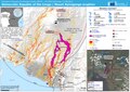
 ECDM 20210409 Soufriere Volcano(1).jpg 2,367 × 2,064; 1.22 MB
-
 ECDM 20210527DRC volcano.pdf 2,479 × 1,754; 1.37 MB
-
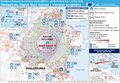
 Hazard Map of Mt.Fuji common l.jpg 1,701 × 2,378; 2.72 MB
-

-
 La Soufriere Pyroclastic Flow Danger.jpg 840 × 1,172; 205 KB
-
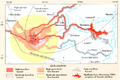 Nevado del Ruiz hazard map, from Wright and Pierson.png 675 × 450; 324 KB
-
 Pinatubo evacuation areas.gif 1,000 × 719; 95 KB
-
 Predicative map of Mt.Fuji volcanic-ash-fall.jpg 720 × 550; 363 KB
-
 Taal Volcano Danger Zone.svg 360 × 215; 474 KB
-
 VAAC Coverage.jpg 3,600 × 2,475; 1.76 MB
-
 Volcanic-ash-downfall map of Mt.Fuji Hoei-eruption01.jpg 1,935 × 1,364; 1.54 MB
-
 Zona rossa Vesuvio.png 942 × 794; 904 KB
.jpg)


