Category:Havenstraat 2, Oudewater
Jump to navigation
Jump to search
| Object location | | View all coordinates using: OpenStreetMap |
|---|
building in Oudewater, Netherlands  | |||||
| Upload media | |||||
| Instance of | |||||
|---|---|---|---|---|---|
| Location | Oudewater, Utrecht, Netherlands | ||||
| Street address |
| ||||
| Located on street |
| ||||
| Heritage designation |
| ||||
 | |||||
|
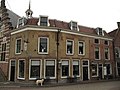
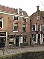
This is a category about rijksmonument number 32018
|
| Address |
|
Media in category "Havenstraat 2, Oudewater"
The following 6 files are in this category, out of 6 total.
-
 3421 Oudewater, Netherlands - panoramio (58).jpg 2,048 × 1,148; 627 KB
-
 Overzicht - Oudewater - 20179851 - RCE.jpg 879 × 1,200; 179 KB
-
 Overzicht met kerktoren - Oudewater - 20375986 - RCE.jpg 974 × 1,200; 208 KB
-
 RM32011 Oudewater - Havenstraat 1.jpg 2,592 × 1,944; 1.31 MB
-
 RM32018 Oudewater - Havenstraat 2.jpg 1,944 × 2,592; 1.36 MB
-
 Voorgevels - Oudewater - 20179850 - RCE.jpg 1,200 × 806; 216 KB
.jpg)


