Category:Haut-Martelange
Jump to navigation
Jump to search
Internationalization
Deutsch: Obermartelingen
Français : Haut-Martelange
Lëtzebuergesch: Uewermaarteleng
| Object location | | View all coordinates using: OpenStreetMap |
|---|
village in Luxembourg  | |||||
| Upload media | |||||
| Pronunciation audio | |||||
|---|---|---|---|---|---|
| Instance of | |||||
| Location | Rambrouch, Canton of Redange, Luxembourg | ||||
| Population |
| ||||
| Different from | |||||
 | |||||
Subcategories
This category has the following 2 subcategories, out of 2 total.
H
M
Media in category "Haut-Martelange"
The following 5 files are in this category, out of 5 total.
-
 Lage Obermartelingens.jpg 105 × 121; 3 KB
-
 Maark 164.jpg 1,880 × 2,819; 757 KB
-
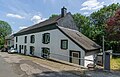 Maison 11 Haut-Martelange 01.jpg 3,189 × 2,050; 6.65 MB
-
 Obermartelingem.jpg 869 × 581; 68 KB
-
 Vue sur Haut-Martelange 2012.JPG 3,000 × 2,000; 2.59 MB


