Category:Haus zur Farb
Jump to navigation
Jump to search
| Object location | | View all coordinates using: OpenStreetMap |
|---|
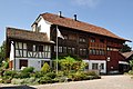
residential building in Stäfa in the canton of Zürich, Switzerland  | |||||
| Upload media | |||||
| Instance of | |||||
|---|---|---|---|---|---|
| Part of | |||||
| Location |
| ||||
| Street address |
| ||||
| Occupant | |||||
| Heritage designation | |||||
 | |||||
Media in category "Haus zur Farb"
The following 20 files are in this category, out of 20 total.
-
 Haus zur Farb Staefa1.jpg 4,520 × 3,003; 10.19 MB
-
 Haus zur Farb Staefa2.jpg 4,912 × 3,264; 11.66 MB
-
 Haus zur Farb Staefa3.jpg 4,912 × 3,264; 10.91 MB
-
 Haus zur Farb Staefa4.jpg 4,912 × 3,264; 11.8 MB
-
 Haus zur Farb Staefa5.jpg 3,264 × 4,912; 11.83 MB
-
 Haus zur Farb Staefa6.jpg 3,264 × 4,912; 10.51 MB
-
 Haus zur Farb Staefa7.jpg 3,264 × 4,912; 10.32 MB
-
 Haus zur Farb, Dorfstrasse 11-15 in Stäfa 2011-08-24 14-29-14 ShiftN.jpg 4,000 × 2,667; 3.45 MB
-
 Stäfa - Haus zur Farb - Dorfstrasse 11-15 2011-08-24 14-27-30 ShiftN.jpg 3,998 × 2,667; 3.14 MB
-
 Stäfa - Haus zur Farb - Dorfstrasse 11-15 2011-08-24 14-27-34.jpg 3,928 × 2,626; 3.22 MB
-
 Stäfa - Haus zur Farb - Dorfstrasse 11-15 2011-08-24 14-28-18 ShiftN.jpg 2,667 × 4,000; 3.16 MB
-
 Stäfa - Haus zur Farb - Dorfstrasse 11-15 2011-08-24 14-28-42.jpg 4,000 × 2,667; 3.14 MB
-
 Stäfa - Haus zur Farb - Dorfstrasse 11-15 2011-08-24 14-29-02 ShiftN.jpg 3,999 × 2,667; 3.23 MB
-
 Stäfa - Haus zur Farb - Dorfstrasse 11-15 2011-08-24 14-29-20 ShiftN.jpg 2,667 × 4,000; 3.42 MB
-
 Stäfa - Haus zur Farb - Dorfstrasse 11-15 2011-08-24 14-29-38.jpg 2,667 × 4,000; 2.88 MB
-
 Stäfa - Haus zur Farb - Dorfstrasse 11-15 2011-08-24 14-29-56.jpg 2,667 × 4,000; 2.64 MB
-
 Stäfa - Haus zur Farb - Dorfstrasse 11-15 2011-08-24 14-32-08.JPG 4,288 × 2,848; 3.79 MB
-
 Stäfa Haus zur Farb01.JPG 2,816 × 2,112; 1.8 MB
-
 Stäfa Haus zur Farb02.JPG 2,816 × 2,112; 1.6 MB
-
 Stäfa Haus zur Farb03.JPG 2,816 × 2,112; 1.71 MB


