Category:Haus Stoffel, Fürstenau
Jump to navigation
Jump to search
| Object location | | View all coordinates using: OpenStreetMap |
|---|
 | |||||
| Upload media | |||||
| Instance of | |||||
|---|---|---|---|---|---|
| Part of | |||||
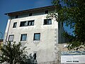
| Location | Fürstenau, Domleschg, Hinterrhein District, Grisons, Switzerland | ||||
| Street address |
| ||||
| Heritage designation | |||||
 | |||||
|
This is a category about a cultural property of national significance in Switzerland with KGS number 3020
|
Media in category "Haus Stoffel, Fürstenau"
The following 3 files are in this category, out of 3 total.
-
 FürstenauStoffelhaus.JPG 1,600 × 1,200; 748 KB
-
 Stoffelhaus01.jpg 1,600 × 1,200; 942 KB
-
 Stoffelhaus02.jpg 1,600 × 1,200; 934 KB

