Category:Haus Nr. 135 (Wittwil, Staffelbach)
Jump to navigation
Jump to search
| Object location | | View all coordinates using: OpenStreetMap |
|---|
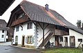
rural dwelling house in Wittwil in the canton of Aargau, Switzerland  | |||||
| Upload media | |||||
| Instance of | |||||
|---|---|---|---|---|---|
| Part of | |||||
| Location | Wittwil, Zofingen District, Aargau, Switzerland | ||||
| Street address |
| ||||
| Heritage designation | |||||
| Inception |
| ||||
 | |||||
Media in category "Haus Nr. 135 (Wittwil, Staffelbach)"
The following 2 files are in this category, out of 2 total.
-
 Staffelbach Haus Wittwil 135.jpg 3,208 × 2,231; 1.69 MB
-
 Staffelbach Wittwil1 Haus 135.jpg 4,065 × 2,592; 3.48 MB
