Category:Haus Ley
Jump to navigation
Jump to search
| Object location | | View all coordinates using: OpenStreetMap |
|---|
 | |||||
| Upload media | |||||
| Instance of | |||||
|---|---|---|---|---|---|
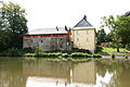
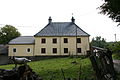
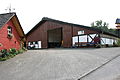
| Location | Engelskirchen, Oberbergischer Kreis, Cologne Government Region, North Rhine-Westphalia, Germany | ||||
| Heritage designation | |||||
 | |||||
Media in category "Haus Ley"
The following 10 files are in this category, out of 10 total.
-
 Engelskirchen Bellingroth - Haus Ley2 01 ies.jpg 3,888 × 2,592; 3.04 MB
-
 Engelskirchen Bellingroth - Haus Ley2 02 ies.jpg 3,888 × 2,592; 3.01 MB
-
 Engelskirchen Bellingroth - Haus Ley2 03 ies.jpg 3,888 × 2,592; 4.21 MB
-
 Engelskirchen Bellingroth - Haus Ley2 04 ies.jpg 3,888 × 2,592; 2.45 MB
-
 Engelskirchen Bellingroth - Haus Ley2 05 ies.jpg 3,888 × 2,592; 2.58 MB
-
 Engelskirchen Bellingroth - Haus Ley2 06 ies.jpg 3,888 × 2,592; 2.76 MB
-
 Engelskirchen Bellingroth - Haus Ley2 07 ies.jpg 3,888 × 2,592; 2.53 MB
-
 Engelskirchen Bellingroth - Haus Ley2 08 ies.jpg 3,888 × 2,592; 2.44 MB
-
 Engelskirchen Bellingroth - Haus Ley2 09 ies.jpg 3,888 × 2,592; 1.51 MB
-
 Engelskirchen Bellingroth - Haus Ley2 10 ies.jpg 3,888 × 2,592; 2.07 MB


