Category:Hauptstraße 48 (Roth bei Nürnberg)
Jump to navigation
Jump to search
| Object location | | View all coordinates using: OpenStreetMap |
|---|
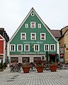
This is the category of the Bavarian Baudenkmal (cultural heritage monument) with the ID D-5-76-143-49 (Wikidata)
|
Deutsch: Roth - Hauptstraße 48 - Gasthaus. Zweigeschossiger Giebelbau, im Kern 16./17.Jahrhundert, Fassade um 1906/07.
building in Roth, Bavaria, Germany  | |||||
| Upload media | |||||
| Instance of | |||||
|---|---|---|---|---|---|
| Location | Roth, Middle Franconia, Bavaria, Germany | ||||
| Street address |
| ||||
| Heritage designation | |||||
 | |||||
Media in category "Hauptstraße 48 (Roth bei Nürnberg)"
The following 4 files are in this category, out of 4 total.
-
 Roth bei Nürnberg - Hauptstraße 48 - 01.jpg 3,355 × 4,194; 5.02 MB
-
 Roth bei Nürnberg - Hauptstraße 48 - Detail 01.jpg 4,172 × 2,781; 4.34 MB
-
 Roth bei Nürnberg - Hauptstraße 48 - Detail 02.jpg 4,512 × 3,008; 4.27 MB
-
 Roth, Hauptstraße 48, 001.jpg 4,928 × 3,264; 10.32 MB


