Category:Hauptstraße 21, 23 (Roth bei Nürnberg)
Jump to navigation
Jump to search
| Object location | | View all coordinates using: OpenStreetMap |
|---|
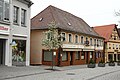
building in Roth, Bavaria, Germany  | |||||
| Upload media | |||||
| Instance of | |||||
|---|---|---|---|---|---|
| Location | Roth, Middle Franconia, Bavaria, Germany | ||||
| Street address |
| ||||
| Heritage designation | |||||
 | |||||
This is the category of the Bavarian Baudenkmal (cultural heritage monument) with the ID D-5-76-143-30 (Wikidata)
|
Deutsch: Roth - Hauptstraße 21, 23 - Bürgerhaus. Langgestreckter zweigeschossiger Walmdachbau, 18. /frühes 19. Jahrhundert; dazu Stadtmauerrest, 14. Jahrhundert.
Media in category "Hauptstraße 21, 23 (Roth bei Nürnberg)"
The following 3 files are in this category, out of 3 total.
-
 Roth bei Nürnberg - Hauptstraße 21, 23 - 01.jpg 4,404 × 2,936; 5.97 MB
-
 Roth, Hauptstraße 21, 23a, 23b 001.jpg 4,928 × 3,264; 10.73 MB
-
 Where Are Ü Now That I Need You (27857770571).jpg 2,048 × 1,360; 1.03 MB

.jpg)
Categories:
- Hauptstraße (Roth bei Nürnberg)
- Houses in Roth (bei Nürnberg)
- Commerce buildings in Roth (bei Nürnberg)
- Cultural heritage monuments in Roth (bei Nürnberg)
- City walls of Roth (bei Nürnberg)
- 14th-century architecture in Roth (bei Nürnberg)
- 18th-century architecture in Roth (bei Nürnberg)
- 19th-century architecture in Roth (bei Nürnberg)