
Category:Hauptdienstgebäude (Rangierbahnhof Basel-Muttenz)
| Object location | | View all coordinates using: OpenStreetMap |
|---|
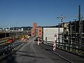
service building in Muttenz in the canton of Basel-Landschaft, Switzerland  | |||||
| Upload media | |||||
| Instance of |
| ||||
|---|---|---|---|---|---|
| Part of | |||||
| Location | Muttenz, Arlesheim District, Basel-Landschaft, Switzerland | ||||
| Street address |
| ||||
| Architect |
| ||||
| Heritage designation | |||||
| Inception |
| ||||
 | |||||
Media in category "Hauptdienstgebäude (Rangierbahnhof Basel-Muttenz)"
The following 10 files are in this category, out of 10 total.
-
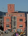
 Hauptdienstgebäude Rangierbahnhof Muttenz.jpg 2,592 × 1,936; 672 KB
-
 Hauptdienstgebäude, Rangierbahnhof Basel-Muttenz, 1956 (ETH-BIB-LBS H1-019262).tif 2,049 × 1,203; 2.39 MB
-
 Hauptdienstgebäude, Rangierbahnhof Basel-Muttenz, 2022.jpg 223 × 284; 55 KB
-
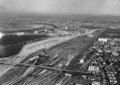 ETH-BIB-Muttenz, Bahnhof-LBS H1-027748.tif 5,713 × 4,045; 66.16 MB
-
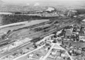
 ETH-BIB-Muttenz, Rangierbahnhof-LBS H1-019261.tif 6,491 × 4,489; 83.46 MB
-
 ETH-BIB-Muttenz-LBS H1-019262.tif 6,453 × 4,549; 84.06 MB
-
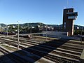 Rangierbahnhof Basel-Muttenz 10.jpg 1,300 × 975; 934 KB
-
 Rangierbahnhof Basel-Muttenz 4.jpg 1,300 × 975; 813 KB
-
 Rangierbahnhof Basel-Muttenz 5.jpg 1,300 × 975; 906 KB
-
 Rangierbahnhof Basel-Muttenz 7.jpg 1,300 × 975; 985 KB


