Category:Harlot Hill Tower
Jump to navigation
Jump to search
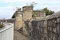
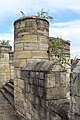
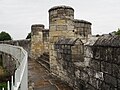
English: Harlot Hill Tower (Tower 31) with city wall, rampart and ditch. 13th-century and later. Part of Grade I listed City walls from Bootham Bar to Layerthorpe (qv).
Media in category "Harlot Hill Tower"
The following 12 files are in this category, out of 12 total.
-
 City Walls - Jewbury - geograph.org.uk - 2356219.jpg 640 × 480; 140 KB
-
 City Walls near Foss Islands - geograph.org.uk - 2356224.jpg 640 × 480; 142 KB
-
 Harlots' Tower (27106273622).jpg 2,875 × 2,994; 6.9 MB
-
 Tour Harlot Hill York 1.jpg 3,456 × 5,184; 7.07 MB
-
 Tour Harlot Hill York 2.jpg 5,184 × 3,456; 7.3 MB
-
 Tour Harlot Hill York 3.jpg 3,456 × 5,184; 9.21 MB
-
 Tour Harlot Hill York 4.jpg 3,456 × 5,184; 8.13 MB
-
 Tower 31 Harlot Hill Tower 01.jpg 4,387 × 3,290; 3.34 MB
-
 Tower 31 Harlot Hill Tower 02.jpg 4,608 × 3,456; 5.77 MB
-
 Walls near Foss Islands - geograph.org.uk - 2354931.jpg 480 × 640; 163 KB
-
 York city walls from Layerthorpe Bridge to Monk Bar (5).JPG 4,608 × 3,440; 4.11 MB
-
 York, City walls near Monk Bar - geograph.org.uk - 1508085.jpg 640 × 552; 73 KB


.jpg)


.JPG)
