Category:Hammestein (Leidschendam)
Jump to navigation
Jump to search
| Object location | | View all coordinates using: OpenStreetMap |
|---|
 | |||||
| Upload media | |||||
| Instance of | |||||
|---|---|---|---|---|---|
| Location | Leidschendam, Leidschendam-Voorburg, South Holland, Netherlands | ||||
| Street address |
| ||||
| Located on street |
| ||||
| Heritage designation |
| ||||
 | |||||
Nederlands: Hammestein
|
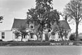
This is a category about rijksmonument number 25727
|
| Address |
|
Media in category "Hammestein (Leidschendam)"
The following 2 files are in this category, out of 2 total.
-
 Hammestein", aanzicht - Leidschendam - 20138101 - RCE.jpg 1,200 × 811; 283 KB
-
 Veursestraatweg 207 'Hammestein' Rijksmonument 25727.jpg 3,648 × 2,736; 4.24 MB
