Category:Hakatai Shale
Jump to navigation
Jump to search
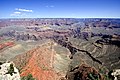
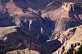
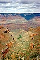
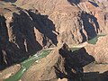
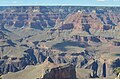
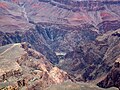
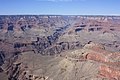
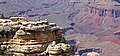
English: The extremely colorful (orange, reds)-Hakatai Shale, above the lowest Bass Limestone member, Unkar Group, of the Grand Canyon Supergroup. Part of the oldest geologic units in the Grand Canyon, Arizona, USA.
Unkar Group members:
- 5—(w:Cardenas Basalt, Cardenas Lava(Cardenas Lavas))-(erosion resistant, island: Tapeats Sandstone-(of Tapeats Sea), only deposited horizontally on "mountain island"-perimeter
4--Dox Formation
3--Shinumo Quartzite-(erosion resistant, island: Tapeats Sandstone-(of Tapeats Sea), only deposited horizontally on "mountain island"-perimeter
X--Diabase Sills
2--Hakatai Shale
1--Bass Limestone, (on Vishnu Schist)
Mesoproterozoic rock formation | |||||
| Upload media | |||||
| Instance of | |||||
|---|---|---|---|---|---|
| Location |
| ||||
| |||||
Subcategories
This category has the following 3 subcategories, out of 3 total.
H
- Hakatai Shale slopes (47 F)
Media in category "Hakatai Shale"
The following 67 files are in this category, out of 67 total.
-
 2012.09.14.084856 View Mather Point Grand Canyon Arizona.jpg 1,920 × 1,280; 1.09 MB
-
 2012.09.14.085514 View Mather Point Grand Canyon Arizona.jpg 1,920 × 1,280; 1.19 MB
-
 2012.09.14.121803 View Yavapai Point Grand Canyon Arizona.jpg 1,920 × 1,280; 1.47 MB
-
 2012.09.14.155225 View South Rim Trail Grand Canyon Arizona.jpg 1,920 × 1,280; 1.2 MB
-
 2012.09.14.155238 View South Rim Trail Grand Canyon Arizona.jpg 1,920 × 1,280; 1 MB
-
 2012.09.14.160505 Rock South Rim Trail Grand Canyon Arizona.jpg 1,920 × 1,280; 1.29 MB
-
 2012.09.14.161647 View South Rim Trail Grand Canyon Arizona.jpg 1,920 × 1,280; 1.1 MB
-
 2012.09.14.172506 View Maricopa Point Grand Canyon Arizona.jpg 1,920 × 1,280; 1.39 MB
-
 2012.09.14.172516 View Maricopa Point Grand Canyon Arizona.jpg 1,920 × 1,280; 1.17 MB
-
 Beautiful view of the Grand Canyon.JPG 2,816 × 2,112; 1.82 MB
-
 Bright Angel Trail Plateau Point.jpg 3,008 × 2,000; 3.79 MB
-
 Bright Angel Trail, Grand Canyon - panoramio.jpg 2,960 × 1,050; 3.01 MB
-
 Colorado River view from South Kaibab Trail.JPG 5,184 × 3,456; 7.97 MB
-
 Deep chasm - Grand Canyon National Park.jpeg 1,280 × 960; 695 KB
-
 Desert View Grandview 2 (15359257880).jpg 5,184 × 3,456; 11.7 MB
-
 Desert View Grandview 3 (15358762918).jpg 3,456 × 4,973; 8.69 MB
-
 Desert View Grandview 4 (14924164204).jpg 5,184 × 3,456; 8.79 MB
-
 DSC3863 HDR - panoramio.jpg 2,456 × 1,638; 2.79 MB
-
 El cañón grandioso, 9-15 (30597718082).jpg 2,800 × 2,016; 2.6 MB
-
 First canyon view.jpg 1,600 × 1,067; 914 KB
-
 First River Sighting (17217975992).jpg 3,968 × 2,976; 4.43 MB
-
 Gcnp symmetry.jpg 2,000 × 1,500; 2.92 MB
-
 Grand Canyon (1).jpg 3,000 × 2,000; 2.64 MB
-
 Grand Canyon 09 2017 5150.jpg 3,000 × 2,000; 6.69 MB
-
 Grand Canyon cloud.jpg 603 × 900; 211 KB
-
 Grand Canyon from Plateau Point - Flickr - brewbooks (1).jpg 3,264 × 2,448; 4.49 MB
-

-
 Grand Canyon NP Ar Granite Gorge Plateau Point ne PICT0075 19941027.jpg 1,680 × 2,520; 2.25 MB
-
 Grand Canyon Ooh Aah Point.png 9,115 × 3,628; 46.76 MB
-
 Grand Canyon Rim Trail 2019 6.jpg 4,928 × 3,264; 9.21 MB
-
 Grand Canyon Rim Trail 2019 8.jpg 4,928 × 3,264; 9.63 MB
-
 Grand Canyon Supergroup Hakatai Shale 0002 - Flickr - Grand Canyon NPS.jpg 3,008 × 2,000; 1.21 MB
-
 Grand Canyon Supergroup with basalt dike in Hakatai Shale.JPG 800 × 526; 104 KB
-
 Grand Canyon Vincent Bloch.jpg 2,560 × 1,920; 3.28 MB
-
 Grand Canyon with Snow 4.JPG 4,000 × 3,000; 10.02 MB
-
 Grand Canyon, Arizona, National Park.jpg 4,565 × 3,045; 10.32 MB
-
 Grand Canyon, Arizona, États-Unis. (Arizona).jpg 4,320 × 3,240; 4.31 MB
-
 Grand Canyon, from Grandview Point (7902128248).jpg 4,272 × 2,848; 6 MB
-
 Grand Canyon, from Mather Point (7901981906).jpg 4,272 × 2,848; 5.63 MB
-
 Grand Canyon, Near El Tovar Hotel.JPG 3,264 × 2,448; 2.25 MB
-
 Grand Canyon, near Yaki Point Rd 01.jpg 3,264 × 4,912; 8.63 MB
-
 Grand Canyon, North Rim sunset 1989.jpg 1,007 × 701; 143 KB
-
 Grand Canyon, South Rim IMG 4547.jpg 4,040 × 3,150; 6.59 MB
-
 Grand Canyon, South Rim IMG 4560.jpg 4,364 × 2,043; 5.15 MB
-
 Grand Canyon, South Rim IMG 4575.jpg 6,000 × 4,000; 8.35 MB
-
 Grand Canyon, South Rim IMG 4579.jpg 4,014 × 3,605; 4.14 MB
-
 Grand Canyon, South Rim Mather Look-out Point - panoramio.jpg 4,224 × 2,748; 2.38 MB
-
 Grand Canyon2017.jpg 1,509 × 1,885; 685 KB
-
 Grand canyons hill.jpg 1,280 × 960; 311 KB
-
 Heading Down, Grand Canyon 9-15 (22083254922).jpg 2,800 × 2,526; 2.99 MB
-
 Hopi Point (8052507434).jpg 4,256 × 2,832; 3.6 MB
-
 Hopi Point Grand Canyon 3 (15544283645).jpg 3,456 × 5,184; 13.03 MB
-
 Kanion Kolorado2004.jpg 1,600 × 1,200; 229 KB
-
 Looks Good in Sunset Colors (17193908526).jpg 2,589 × 3,452; 3.72 MB
-
 Mather Point, Grand Canyon, AZ - panoramio.jpg 1,600 × 1,200; 831 KB
-
 Panorama du Grand Canyon de soir.JPG 9,231 × 2,332; 5.01 MB
-
 Plateau Point - Pipe Springs Rapids (I think) - Flickr - brewbooks.jpg 3,264 × 2,448; 3.91 MB
-
 Sunrise on the S rim of the Grand Canyon - (13843275485).jpg 2,121 × 1,414; 3.1 MB
-
 The Grand Canyon (17) (8096304514).jpg 3,264 × 2,448; 7.31 MB
-
 The Grand Canyon Arizona. (14901312411).jpg 2,400 × 1,497; 6.51 MB
-
 The Grand Canyon. (12124856486).jpg 3,232 × 1,732; 5.78 MB
-
 TheGrandCanyon.JPG 2,304 × 1,728; 2.2 MB
-
 Vue sur le Grand Canyon depuis un belvédère (9069270382).jpg 3,939 × 2,216; 11.14 MB
-
 Ylgdc db (16212983324).jpg 2,240 × 2,574; 2.01 MB
-

-
-


.jpg)
.jpg)
.jpg)

.jpg)

.jpg)

.jpg)


.jpg)


.jpg)
.jpg)
.jpg)


.jpg)
.jpg)
.jpg)

.jpg)

_-_Flickr_-_brewbooks.jpg)
.jpg)
_(8096304514).jpg)
.jpg)
.jpg)

.jpg)
.jpg)


Categories:
- Unkar Group
- Grand Canyon basement rock geology
- Geologic formations in Arizona
- Mesoproterozoic formations in Arizona
- Mesoproterozoic sedimentary rocks in Arizona
- Shale formations in Arizona
- Sandstone formations in Arizona
- Mesoproterozoic shale in the United States
- Mesoproterozoic sandstone in the United States
- Fossil bearing geologic formations in Arizona
- Stromatolites in the United States
- Mesoproterozoic fossil bearing formations in the United States
- Iron oxidations in Arizona