Category:Hagbergturm
Jump to navigation
Jump to search
| Object location | | View all coordinates using: OpenStreetMap |
|---|
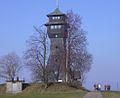
observation tower on Hagberg mountain  | |||||
| Upload media | |||||
| Instance of | |||||
|---|---|---|---|---|---|
| Named after |
| ||||
| Made from material | |||||
| Location | Horlachen, Gschwend, Ostalbkreis, Stuttgart Government Region, Baden-Württemberg, Germany | ||||
| Operator | |||||
| Height |
| ||||
 | |||||
Media in category "Hagbergturm"
The following 9 files are in this category, out of 9 total.
-
 2015 Hagbergturm Gschwend.jpg 4,453 × 3,305; 5.44 MB
-
 Hagbergturm Panorama Ost.jpg 8,921 × 2,687; 10.74 MB
-
 Hagbergturm-01.jpg 3,163 × 4,217; 6.98 MB
-
 Hagbergturm-02.jpg 3,240 × 4,320; 4.77 MB
-
 Hagbergturm-03-untere Plattform.jpg 4,320 × 3,240; 5.61 MB
-
 Hagbergturm-04-obere Plattform.jpg 4,320 × 3,240; 5.51 MB
-
 Hagbergturm-05-Infotafel.jpg 4,320 × 3,240; 5.41 MB
-
 Hagbergturm-2010.jpg 1,600 × 1,200; 635 KB
-
 Hagbergturm.jpg 982 × 800; 83 KB


