Category:Habitatge al carrer Gurb, 32-36
Jump to navigation
Jump to search
| Object location | | View all coordinates using: OpenStreetMap |
|---|
house in Vic, Spain  | |||||
| Upload media | |||||
| Instance of | |||||
|---|---|---|---|---|---|
| Location | Vic, Osona, Catalunya Central, Catalonia | ||||
| Architectural style | |||||
| Heritage designation |
| ||||
 | |||||
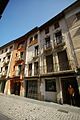
Català: Habitatge al carrer Gurb, 32-36, - Pla de Balenyà (Vic)
This is a category about a building listed in the Catalan heritage register as Bé Cultural d'Interès Local (BCIL) under the reference IPA-24696. |
Media in category "Habitatge al carrer Gurb, 32-36"
The following 4 files are in this category, out of 4 total.
-
 081 Casa al c. Gurb, 32 (Vic).jpg 2,112 × 2,816; 2.01 MB
-
 107 Cases al c. Gurb, 32-36 (Vic).jpg 2,816 × 2,112; 1.9 MB
-
 Vic c.Gurb-32-36 IPA24696 0664 resize.jpg 800 × 1,200; 331 KB
-
 Vic c.Gurb-32-36 IPA24696 0667 resize.jpg 800 × 1,200; 393 KB
.jpg)
.jpg)
