Category:HDI maps of subnational entities
Jump to navigation
Jump to search
This is a category for maps of subnational entities.
Media in category "HDI maps of subnational entities"
The following 62 files are in this category, out of 62 total.
-
 Administrative divisions of China by HDI (2017).svg 512 × 427; 122 KB
-
 Administrative divisions of China by HDI (2019).svg 512 × 427; 115 KB
-
 Angolan provinces by HDI (2017).svg 512 × 546; 134 KB
-
 Armenian provinces by HDI (2017).svg 512 × 523; 83 KB
-
 Australian states by HDI (2017).svg 512 × 469; 60 KB
-
 Austrian states by HDI (2017).svg 512 × 278; 72 KB
-
 Belgian provinces by HDI (2017).svg 512 × 448; 142 KB
-
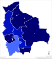 Bolivian departments by HDI (2017).svg 512 × 584; 190 KB
-
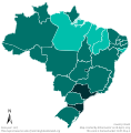 Brazilian states by HDI (2017).svg 512 × 521; 203 KB
-
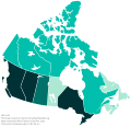
 Canadian provinces and territories by HDI (2015).svg 512 × 493; 103 KB
-
 Canadian provinces and territories by HDI (2018).svg 512 × 493; 91 KB
-
 Canadian provinces and territories by HDI (2019).svg 512 × 493; 48 KB
-
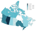 Canadian provinces and territories by HDI (2021).png 3,699 × 3,224; 759 KB
-
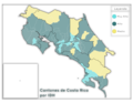 Cantones de Costa Rica por IDH.png 2,112 × 1,632; 274 KB
-
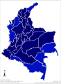 Colombian departments by HDI (2017).svg 512 × 697; 354 KB
-
 Counties of Croatia by HDI (2018).svg 512 × 514; 254 KB
-
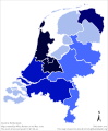 Dutch provinces by HDI (2017).svg 512 × 621; 102 KB
-
 Ecuadorian provinces by HDI (2017).svg 512 × 614; 242 KB
-
 Federal subjects of Russia by HDI (2016).svg 512 × 303; 180 KB
-
 Governorates of Egypt by HDI (2017).svg 512 × 492; 245 KB
-
 Governorates of Iraq by HDI (2017).svg 512 × 513; 142 KB
-
 Indian states and territories by HDI (2017).svg 512 × 612; 203 KB
-
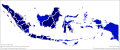 Indonesian provinces by HDI (2019).svg 512 × 213; 347 KB
-
 Iranian provinces by HDI (2017).svg 512 × 490; 134 KB
-
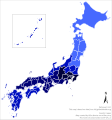 Japanese prefectures by HDI (2017).svg 512 × 547; 311 KB
-
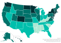 Map of the U.S. states by Human Development Index (2018).svg 512 × 354; 81 KB
-
 Map of U.S. states by Human Development Index (2017).svg 512 × 350; 85 KB
-
 Mapa cantonal de Costa Rica de IDH 2020.png 2,480 × 2,402; 472 KB
-
 Mapa dos estados brasileiros por IDH (2021).svg 775 × 758; 205 KB
-
 Mexican states by HDI (2019).svg 512 × 350; 150 KB
-
 Peruvian departments by HDI (2017).svg 512 × 728; 89 KB
-
 Polish voivodeships by HDI (2017).svg 512 × 512; 92 KB
-
 Provinces of Argentina by HDI (2016).svg 512 × 1,251; 246 KB
-
 Provinces of Argentina by HDI (2021).svg 512 × 1,251; 224 KB
-
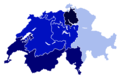 Regional HDI of Switzerland 2021.png 1,280 × 870; 139 KB
-
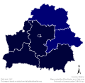 Regions of Belarus by HDI (2017).svg 512 × 503; 183 KB
-
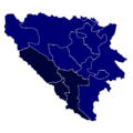 Regions of Bosnia and Herzegovina by HDI (2021).png 500 × 500; 120 KB
-
 Regions of Chile by HDI (2017).svg 512 × 1,889; 534 KB
-
 Regions of Denmark by HDI (2017).svg 512 × 633; 135 KB
-
 Regions of Finland by HDI (2017).svg 512 × 902; 106 KB
-
 Regions of France by HDI (2017).svg 512 × 524; 104 KB
-
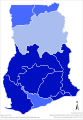 Regions of Ghana by HDI (2017).svg 512 × 735; 132 KB
-
 Regions of Hungary by HDI (2017).svg 512 × 333; 121 KB
-
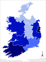 Regions of Ireland by HDI (2017).svg 512 × 676; 409 KB
-
 Regions of Italy by HDI (2017).svg 512 × 629; 236 KB
-
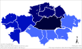 Regions of Kazakhstan by HDI (2018).svg 512 × 306; 208 KB
-
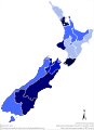 Regions of New Zealand by HDI (2017).svg 512 × 705; 224 KB
-
 Regions of Norway by HDI (2017).svg 512 × 557; 76 KB
-
 Regions of Portugal by HDI (2017).svg 512 × 885; 207 KB
-
 Regions of Portugal by HDI (2019).svg 512 × 885; 501 KB
-
 Regions of South Korea by HDI (2017).svg 512 × 792; 287 KB
-
 Regions of Sweden by HDI (2017).svg 512 × 1,192; 105 KB
-
 Regions of Switzerland by HDI (2018).svg 512 × 347; 169 KB
-
 Regions of the United Kingdom by HDI (2017).svg 512 × 909; 1.18 MB
-
 Regions of the United Kingdom by HDI (2021).png 2,645 × 4,341; 386 KB
-
 Regions of Turkey by HDI (2018).svg 512 × 263; 271 KB
-
 Regions of Ukraine by HDI (2017).svg 512 × 352; 494 KB
-
 South African provinces by HDI (2017).svg 512 × 453; 273 KB
-
 Spanish autonomous communities by HDI (2017).svg 512 × 431; 216 KB
-
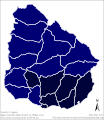 Uruguayan departments by HDI (2017).svg 512 × 589; 90 KB
-
 Uruguayan departments by HDI (2021).svg 512 × 589; 444 KB
-
 Venezuelan states by HDI (2017).svg 512 × 447; 90 KB
.svg)
.svg)
.svg)
.svg)
.svg)
.svg)
.svg)
.svg)
.svg)
.svg)
.svg)
.svg)
.png)

.svg)
.svg)
.svg)
.svg)
.svg)
.svg)
.svg)
.svg)
.svg)
.svg)
.svg)
.svg)
.svg)

.svg)
.svg)
.svg)
.svg)

.svg)
.png)
.svg)
.svg)
.svg)
.svg)
.svg)
.svg)
.svg)
.svg)
.svg)
.svg)
.svg)
.svg)
.svg)
.svg)
.svg)
.svg)
.png)
.svg)
.svg)
.svg)
.svg)
.svg)
.svg)
.svg)
.svg)
.svg)
.svg)