Category:HAER No. ID-4 (Thatcher Bridge)
Jump to navigation
Jump to search
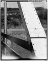
English: Thatcher Bridge, Spanning Bear River, Thatcher, Franklin County, ID. (Historic American Engineering Record images, http://www.loc.gov/pictures/item/id0035/).
- Photographs were taken by Williams Photography, photographer, in May 1982.
| Object location | | View all coordinates using: OpenStreetMap |
|---|
Media in category "HAER No. ID-4 (Thatcher Bridge)"
The following 9 files are in this category, out of 9 total.