Category:Hölzel projection
Jump to navigation
Jump to search
| Upload media | |||||
| |||||
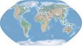
English: Hölzel projection (Hoelzel projection) is a pseudocylindrical map projection. The length of polar line is half that of the equator; and lines of longitude are sinusoids, near the poles ellipsoids; lines of latitude are equal spaces straights.
Subcategories
This category has only the following subcategory.
M
- Maps with Hölzel projection (7 F)
Media in category "Hölzel projection"
The following 3 files are in this category, out of 3 total.
-
 Hoelzel10ost.jpg 10,800 × 6,123; 5.84 MB
-
 Hoelzelbluemarble.png 2,058 × 1,034; 1.56 MB
-
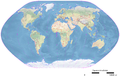 Hoelzelnaturalearth.png 3,038 × 1,944; 6.66 MB


