Category:Hôtel de ville de Charleroi
Jump to navigation
Jump to search
| Object location | | View all coordinates using: OpenStreetMap |
|---|
|
Hôtel de ville de Charleroi has an entry on OpenStreetMap (show). |
This is a category of a copyrighted architecture and/or artistic work in public space from a country that provides Wikimedia Commons-acceptable freedom of panorama (that permits free licensing of images of such works). You can upload more photographs or videos of such works freely. If such works become public domain, please remove this template.
|
|
This is a category about a monument in Wallonia, number: 52011-CLT-0070-01
|
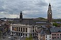
 Hôtel de ville et beffroi. Façade de la place Vauban. | |||||
| Upload media | |||||
| Instance of | |||||
|---|---|---|---|---|---|
| Location | Charleroi, Arrondissement of Charleroi, Hainaut, Walloon Region, Belgium | ||||
| Located on street |
| ||||
| Architectural style | |||||
| Architect | |||||
| Has part(s) | |||||
| Heritage designation |
| ||||
| Inception |
| ||||
 | |||||
Subcategories
This category has the following 3 subcategories, out of 3 total.
B
- Belfry of Charleroi (24 F)
Media in category "Hôtel de ville de Charleroi"
The following 19 files are in this category, out of 19 total.
-
 Charleroi - Emile Maufort et Alexandre Van Malderen - rue du Beffroi.jpg 3,108 × 2,462; 5.64 MB
-
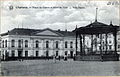
 Charleroi - Hôtel de Ville - 1900.jpg 1,617 × 1,026; 1.74 MB
-
 Charleroi - hôtel de ville - 2024-08-08 - 01.jpg 3,071 × 3,071; 6.57 MB
-
 Charleroi - hôtel de ville - 2024-08-08 - 02.jpg 1,615 × 2,541; 3.18 MB
-
 Charleroi - Hôtel de Ville - Bouclier bleu.jpg 2,304 × 3,072; 2.53 MB
-

-
 Charleroi - Hôtel de ville - salle Dauphin.jpg 852 × 1,280; 971 KB
-
 Charleroi - Hôtel de ville - salle des fêtes - 01.jpg 3,650 × 2,444; 7.41 MB
-
 Charleroi - Hôtel de ville - salle des fêtes - 02.jpg 3,872 × 2,592; 7.37 MB
-
 Charleroi - hôtel de ville vu depuis l'église Saint-Christophe - 01.jpg 4,031 × 2,670; 6.64 MB
-
 Charleroi - Hôtel de ville vu du beffroi - 2016-09-03 - 01.jpg 4,642 × 3,075; 7.69 MB
-
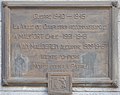
 Charleroi - Hôtel-de-Ville - Libre-sur-Sambre - plaque du 23-09-1994 - 01.jpg 2,196 × 3,035; 6.07 MB
-
 Charleroi - Place du Centre et Hôtel de Ville - Ville Haute.jpg 1,581 × 1,019; 1.52 MB
-
 Charleroi - Place Vauban et Hôtel de ville - 2024-08-11 - 01.jpg 4,595 × 2,585; 8.04 MB
-
 Charleroi - Place Vauban et Hôtel de ville - 2024-08-11 - 02.jpg 4,719 × 2,655; 8.1 MB
-
 Charleroi - rue du Beffroi - école normale provinciale.jpg 1,433 × 2,920; 3.06 MB
-
 Charleroi ratusz 1.jpg 2,747 × 5,184; 7.75 MB
-
 Clocher de l'hôtel de ville vu du beffroi.JPG 1,960 × 3,008; 1.59 MB
-
 Le nouvel hôtel de ville de Charleroi 01.jpg 1,013 × 1,825; 1.58 MB


_-_oblit%C3%A9ration_1911-07-24_-_01.jpg)


