Category:Gwernaffield-y-Waun
Jump to navigation
Jump to search
village in Flintshire, Wales, UK  | |||||
| Upload media | |||||
| Pronunciation audio | |||||
|---|---|---|---|---|---|
| Instance of | |||||
| Location | Gwernaffield with Pantymwyn, Flintshire, Wales | ||||
 | |||||
Media in category "Gwernaffield-y-Waun"
The following 48 files are in this category, out of 48 total.
-
 2010 Wales Flintshire Community Gwernaffield map.svg 512 × 568; 494 KB
-
 Bethel Chapel Plaque, nr Pantymwyn. - geograph.org.uk - 313799.jpg 640 × 457; 221 KB
-
 Dis-used lime kiln near Rhosesmor - geograph.org.uk - 625277.jpg 640 × 480; 88 KB
-
 Footpath and Track at Nant Alyn - geograph.org.uk - 313847.jpg 640 × 480; 250 KB
-
 Halkyn Church - geograph.org.uk - 33773.jpg 512 × 384; 23 KB
-
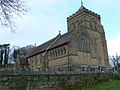
 Holy Trinity Church, Gwernaffield. - geograph.org.uk - 111228.jpg 640 × 480; 113 KB
-
 Old School, Halkyn - geograph.org.uk - 627849.jpg 640 × 480; 87 KB
-
 Plaque on Y Capel Tabernacl, Pantymwyn - geograph.org.uk - 313750.jpg 640 × 457; 179 KB
-
 St Mary's Church, Halkyn.jpg 640 × 480; 84 KB
-
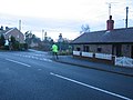 Tiny Cottages - geograph.org.uk - 100758.jpg 640 × 480; 79 KB
-
 Wal garreg Gwernaffield dry stone wall North Wales.JPG 4,272 × 2,848; 7.41 MB
-
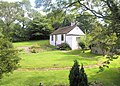
 Bat house - geograph.org.uk - 646165.jpg 640 × 480; 196 KB
-
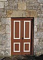 Bethel Chapel Door, near Pantymwyn - geograph.org.uk - 313792.jpg 457 × 640; 182 KB
-
 Bethel Chapel near Pantymwyn - geograph.org.uk - 313787.jpg 640 × 480; 156 KB
-
 Bridge 67 - geograph.org.uk - 313413.jpg 640 × 480; 237 KB
-
 Bridge over the River Alyn - geograph.org.uk - 308905.jpg 640 × 480; 214 KB
-
 Bridge over the River Alyn - geograph.org.uk - 308951.jpg 640 × 480; 239 KB
-
 Bryn Teg - geograph.org.uk - 252760.jpg 300 × 215; 18 KB
-
 Cefn Bychan Road, Pantymwyn - geograph.org.uk - 313698.jpg 640 × 480; 163 KB
-
 Common Land, Halkyn Mountain - geograph.org.uk - 628000.jpg 640 × 480; 104 KB
-
 Cottage at Pantymwyn - geograph.org.uk - 312049.jpg 640 × 480; 156 KB
-
 Cottage in Nant Alyn - geograph.org.uk - 312010.jpg 640 × 480; 78 KB
-
 Crug Farm - geograph.org.uk - 710753.jpg 640 × 480; 107 KB
-
 Field Gate at Pantymwyn - geograph.org.uk - 312048.jpg 640 × 480; 233 KB
-
 Footbridge over the Afon Alun-River Alyn - geograph.org.uk - 311986.jpg 640 × 480; 282 KB
-
 Footbridge over the river Alun- Afon Alyn - geograph.org.uk - 312030.jpg 640 × 513; 139 KB
-
 Footbridge over the River Alyn - geograph.org.uk - 484159.jpg 640 × 480; 128 KB
-
 Footbridge over the River Alyn-Afon Alun - geograph.org.uk - 313435.jpg 640 × 480; 260 KB
-
 Footpath and Stile at Pantymwyn - geograph.org.uk - 313769.jpg 640 × 480; 220 KB
-
 Footpath near Pentre - geograph.org.uk - 710760.jpg 480 × 640; 159 KB
-
 Footpath to Cilcain - geograph.org.uk - 710829.jpg 480 × 640; 75 KB
-
 Footpath to Garth Farm - geograph.org.uk - 710765.jpg 480 × 640; 126 KB
-
 Gate and Gatepost - geograph.org.uk - 313819.jpg 640 × 480; 282 KB
-
 Gate and Stile at Hesp Alyn Farm - geograph.org.uk - 313416.jpg 640 × 480; 249 KB
-
 Here There Be Dragons - geograph.org.uk - 643597.jpg 640 × 480; 204 KB
-
 Leete Path - geograph.org.uk - 577812.jpg 640 × 480; 179 KB
-
 Parish church of St Paul, Rhosesmor - geograph.org.uk - 563432.jpg 600 × 450; 81 KB
-
 Reclaimed land on Halkyn Mountain - geograph.org.uk - 627997.jpg 640 × 480; 80 KB
-
 Redundant Stile on the Leete Path - geograph.org.uk - 313426.jpg 640 × 480; 258 KB
-
 Rhosesmor Sand and Gravel Pit - geograph.org.uk - 203629.jpg 640 × 479; 80 KB
-
 River Alyn Downstream from Pont Newydd - geograph.org.uk - 311022.jpg 640 × 480; 224 KB
-
 River Alyn Upstream from Pont Newydd - geograph.org.uk - 311019.jpg 640 × 480; 244 KB
-
 Road in Nant Alyn - geograph.org.uk - 312019.jpg 640 × 480; 70 KB
-
 Road to Cilcain - geograph.org.uk - 313639.jpg 640 × 480; 236 KB
-
 Rock Face on the Leete Path - geograph.org.uk - 313419.jpg 640 × 480; 258 KB
-
 Stone Bridge over the River Alyn - geograph.org.uk - 313540.jpg 640 × 480; 198 KB
-
 The River Alyn - geograph.org.uk - 311007.jpg 640 × 480; 232 KB
-
 Y Capel Tabernacl, Pantymwyn - geograph.org.uk - 313728.jpg 640 × 480; 136 KB


