Category:Guttenbergplatz 9 (D-5-64-000-2315)
Jump to navigation
Jump to search
| Object location | | View all coordinates using: OpenStreetMap |
|---|
 | |||||
| Upload media | |||||
| Instance of | |||||
|---|---|---|---|---|---|
| Location | Nuremberg, Middle Franconia, Bavaria, Germany | ||||
| Street address |
| ||||
| Heritage designation | |||||
 | |||||
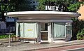
This is the category of the Bavarian Baudenkmal (cultural heritage monument) with the ID D-5-64-000-2315 (Wikidata)
|
Deutsch: Ehem. Blumenpavillon, freistehender, erdgeschossiger Betonbau über eiförmigem Grundriss mit vorderseitig weit vorschwingendem Flachdach und großflächiger Schaufensteranlage, von Heinz Buff, 1958/59.
Media in category "Guttenbergplatz 9 (D-5-64-000-2315)"
The following 4 files are in this category, out of 4 total.
-
 Guttenbergplatz 9 Ehem. Blumenpavillon D-5-64-000-2315 SAM 4993.JPG 4,608 × 3,456; 3.55 MB
-
 Nürnberg Guttenbergplatz 09 001.jpg 2,724 × 2,070; 1.4 MB
-
 Nürnberg Guttenbergplatz 9 001.jpg 4,082 × 2,486; 5.58 MB
-
 Nürnberg Guttenbergplatz 9 002.jpg 4,251 × 2,113; 5.1 MB


