Category:Gunwalloe
Jump to navigation
Jump to search
coastal civil parish and village on the Lizard Peninsula in Cornwall, England  | |||||
| Upload media | |||||
| Instance of | |||||
|---|---|---|---|---|---|
| Named after | |||||
| Location | Cornwall, South West England, England | ||||
| Population |
| ||||
| Elevation above sea level |
| ||||
 | |||||
Subcategories
This category has the following 10 subcategories, out of 10 total.
B
- Berepper (6 F)
C
- Chyvarloe (2 F)
G
- Gunwalloe Fishing Cove (12 F)
H
- HMS Anson Memorial, Loe Bar (5 F)
L
P
- Poldhu Cove, Cornwall (31 F)
Media in category "Gunwalloe"
The following 200 files are in this category, out of 444 total.
(previous page) (next page)-
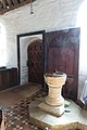 13th century font, St. Winwaloe's church, - geograph.org.uk - 5600882.jpg 1,069 × 1,600; 244 KB
-
 A diversion on the coastal path - geograph.org.uk - 4066744.jpg 3,758 × 2,505; 2.18 MB
-
 A vegetable crop on Halzephron Cliff - geograph.org.uk - 4068176.jpg 3,768 × 2,512; 4.35 MB
-
 Access to Clies Farm - geograph.org.uk - 925979.jpg 640 × 480; 56 KB
-
 Along Halzephron Cliff - geograph.org.uk - 2565555.jpg 640 × 428; 186 KB
-
 Ancient Cornish Cross at St. Winwaloe's church - geograph.org.uk - 5600620.jpg 1,069 × 1,600; 731 KB
-
-
 Arable field south of Nanspean - geograph.org.uk - 3206497.jpg 3,648 × 2,048; 1.75 MB
-
 Baulk Head - geograph.org.uk - 3214183.jpg 3,648 × 2,048; 1.21 MB
-
 Beach at Church Cove, near Gunwalloe Cornwall - geograph.org.uk - 5600926.jpg 1,600 × 1,061; 517 KB
-
 Beach at Jangye-ryn (7914).jpg 4,288 × 2,848; 6.57 MB
-
 Beach at Jangye-Ryn (Dollar Cove) - geograph.org.uk - 5600256.jpg 1,600 × 1,049; 340 KB
-
 Beach at Jangye-Ryn (Dollar Cove) - geograph.org.uk - 5600258.jpg 1,600 × 1,046; 303 KB
-
 Beach cafe at Poldhu, Cornwall - geograph.org.uk - 2370356.jpg 800 × 518; 93 KB
-
 Bentley at Gunwalloe.jpg 2,648 × 2,648; 5.54 MB
-
 Between Poldhu Cove and Church Cove, Gunwalloe - geograph.org.uk - 6698856.jpg 1,024 × 768; 181 KB
-
 Blossom and gate on the track from Chyvarloe to Loe Bar - geograph.org.uk - 4913865.jpg 1,600 × 1,064; 648 KB
-
 Blossom near Loe Bar - geograph.org.uk - 4912622.jpg 1,600 × 1,064; 630 KB
-
 Blue Rocks, Porthleven Sands - geograph.org.uk - 6343734.jpg 2,000 × 1,020; 1.73 MB
-
 Bus up the hill - geograph.org.uk - 6625549.jpg 2,591 × 1,898; 1.25 MB
-
 Buzzard near Gunwalloe - geograph.org.uk - 4068317.jpg 1,029 × 686; 156 KB
-
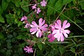 Campion (1428719275).jpg 2,560 × 1,712; 2.04 MB
-
 Carminowe Creek - geograph.org.uk - 1826538.jpg 640 × 426; 44 KB
-
 Carminowe Creek - geograph.org.uk - 1885931.jpg 2,288 × 1,712; 822 KB
-
 Carminowe Creek - geograph.org.uk - 2353699.jpg 640 × 480; 82 KB
-
 Carminowe Creek - geograph.org.uk - 4072061.jpg 3,872 × 2,592; 4.76 MB
-
 Carminowe Creek - geograph.org.uk - 6137085.jpg 1,024 × 680; 165 KB
-
 Carrag-a-pilaz - geograph.org.uk - 3205855.jpg 3,072 × 2,048; 1.59 MB
-

-
 Caterpillar above Porthleven Sands (7876).jpg 4,288 × 2,848; 6.42 MB
-
 Cattle in the long grass - geograph.org.uk - 4050604.jpg 3,872 × 2,592; 7.01 MB
-
 Cave at Gunwalloe (2408451150).jpg 1,712 × 2,560; 4.25 MB
-
 Church Cove (3185037061).jpg 2,426 × 1,631; 3.51 MB
-
 Church Cove (5927).jpg 4,288 × 2,848; 7.01 MB
-
 Church Cove (5928).jpg 4,288 × 2,848; 6.63 MB
-
 Church Cove (5932).jpg 4,288 × 2,848; 6.36 MB
-
 Church Cove (5933).jpg 4,288 × 2,848; 6.98 MB
-
 Church Cove (7916).jpg 4,288 × 2,848; 5.9 MB
-
 Church Cove (7920).jpg 4,288 × 2,848; 6.54 MB
-
 Church Cove (7923).jpg 4,288 × 2,848; 6.21 MB
-
 Church Cove (7924).jpg 4,288 × 2,848; 6.26 MB
-
 Church Cove - geograph.org.uk - 2565441.jpg 640 × 383; 187 KB
-
 Church Cove - geograph.org.uk - 2995784.jpg 800 × 600; 156 KB
-
 Church Cove - geograph.org.uk - 2995797.jpg 800 × 600; 216 KB
-
 Church Cove - geograph.org.uk - 2995805.jpg 800 × 600; 167 KB
-
 Church Cove - geograph.org.uk - 3206256.jpg 3,072 × 2,048; 1.37 MB
-
 Church Cove - geograph.org.uk - 4780853.jpg 640 × 360; 55 KB
-
 Church Cove and St Winwallow's Church (7921).jpg 4,288 × 2,848; 6.47 MB
-
 Church Cove Beach - geograph.org.uk - 5451428.jpg 640 × 480; 51 KB
-
 Church Cove car park - geograph.org.uk - 6182457.jpg 2,000 × 1,322; 2.01 MB
-
 Church Cove from near the church - geograph.org.uk - 1956606.jpg 640 × 426; 59 KB
-
 Church Cove Near Mullion - geograph.org.uk - 5451427.jpg 640 × 480; 50 KB
-
 Church Cove, Cornwall - geograph.org.uk - 6698865.jpg 1,024 × 768; 155 KB
-
 Church Cove, Gunwalloe (2212167351).jpg 1,600 × 1,200; 938 KB
-
 Church Cove, Gunwalloe (4945340389).jpg 2,560 × 1,712; 3.56 MB
-
 Church Cove, Gunwalloe - geograph.org.uk - 1817675.jpg 1,600 × 1,063; 440 KB
-
 Church Cove, Gunwalloe - geograph.org.uk - 4914846.jpg 1,600 × 1,064; 330 KB
-
 Church Cove, Gunwalloe - geograph.org.uk - 4914847.jpg 1,600 × 1,064; 480 KB
-
 Church Cove, Gunwalloe - geograph.org.uk - 4914848.jpg 1,600 × 1,064; 423 KB
-
 Church Cove, Gunwalloe - geograph.org.uk - 4914849.jpg 1,600 × 1,064; 430 KB
-
 Church Cove, Gunwalloe - geograph.org.uk - 6182398.jpg 2,000 × 1,264; 1.92 MB
-
 Church Cove, Gunwalloe - geograph.org.uk - 6182417.jpg 2,000 × 1,476; 2.67 MB
-
 Church Cove, Gunwalloe, seen from the SW Coast Path - geograph.org.uk - 6182409.jpg 2,000 × 1,258; 2.09 MB
-
 Church of Saint Winwaloe - geograph.org.uk - 3206264.jpg 3,072 × 2,048; 1.72 MB
-
 Churchyard and statue, St. Winwaloe's church - geograph.org.uk - 5600921.jpg 1,600 × 1,061; 547 KB
-
 Churchyard of St Winwaloe's church - geograph.org.uk - 2565446.jpg 640 × 427; 197 KB
-
 Churchyard of St Winwaloe, Gunwalloe - geograph.org.uk - 4066721.jpg 3,872 × 2,592; 6.57 MB
-
 Chymder, west of Cury - geograph.org.uk - 4701431.jpg 1,600 × 1,200; 1.12 MB
-
 Cliff south of Church Cove (5934).jpg 4,288 × 2,848; 6.35 MB
-
 Cliffs above Carrag-a-pilaz - geograph.org.uk - 4066694.jpg 3,775 × 2,517; 4.59 MB
-
 Cliffs and Gunwalloe Church Cove (7928).jpg 4,288 × 2,848; 6.21 MB
-
 Cliffs at Jangye-Ryn - geograph.org.uk - 4914332.jpg 1,600 × 1,064; 523 KB
-
 Cliffs at Park Bean Cove - geograph.org.uk - 4914223.jpg 1,600 × 1,064; 386 KB
-
 Cliffs on Jangye-ryn (7911).jpg 4,288 × 2,848; 6.6 MB
-
 Cliffs south of the Loe Bar - geograph.org.uk - 4912695.jpg 1,600 × 1,064; 313 KB
-
 Clubhouse and car park entrance, Mullion Golf Club - geograph.org.uk - 4701429.jpg 1,600 × 1,200; 1.26 MB
-
 Coast at Blue Rocks - geograph.org.uk - 2565633.jpg 640 × 427; 203 KB
-
 Coast at Blue Rocks - geograph.org.uk - 4914099.jpg 1,600 × 1,064; 424 KB
-
 Coast path above Halzephron Cliff - geograph.org.uk - 2111980.jpg 1,024 × 768; 186 KB
-
 Coast path above Porthleven Sands - geograph.org.uk - 2111778.jpg 1,024 × 768; 195 KB
-
 Coast Path, Loe Bar - geograph.org.uk - 1826557.jpg 640 × 410; 39 KB
-
 Coastal Path near Chyvarloe - geograph.org.uk - 2565622.jpg 640 × 429; 201 KB
-
 Coastal path towards Loe Bar - geograph.org.uk - 2565640.jpg 640 × 401; 233 KB
-
 Coastline at Jangye-ryn - geograph.org.uk - 2565530.jpg 640 × 425; 207 KB
-

-

-
 Cove near Jangye-Ryn - geograph.org.uk - 6010220.jpg 640 × 427; 294 KB
-
 Cows near Gunwalloe - geograph.org.uk - 4066753.jpg 3,745 × 2,496; 3.46 MB
-
 Cyclists on Loe Bar - geograph.org.uk - 2565967.jpg 640 × 427; 190 KB
-
 Descent to a river valley - geograph.org.uk - 4050391.jpg 3,872 × 2,592; 6.17 MB
-

-
 Dragonfly by stream at Church Cove, Cornwall - geograph.org.uk - 6698875.jpg 1,024 × 769; 165 KB
-
 Drainage works on Loe Bar - geograph.org.uk - 6343740.jpg 2,000 × 763; 1.36 MB
-
 England SepOkt 19 0478.jpg 5,626 × 3,165; 4.8 MB
-

-
 Entrance to Hingey Farm - geograph.org.uk - 1826583.jpg 640 × 426; 49 KB
-
 Field above Gunwalloe Fishing Cove - geograph.org.uk - 4068338.jpg 3,704 × 2,469; 1.76 MB
-
 Field and Chyanvounder (7887).jpg 4,288 × 2,848; 6.3 MB
-
 Field and Chyanvounder (7888).jpg 4,288 × 2,848; 6.32 MB
-
 Field entrance above Loe Bar - geograph.org.uk - 4071959.jpg 3,872 × 2,592; 5.31 MB
-
 Field entrance near Chyvarloe - geograph.org.uk - 4071992.jpg 3,872 × 2,592; 5.53 MB
-
 Field inland from Chyanvounder - geograph.org.uk - 4050333.jpg 3,872 × 2,592; 5.37 MB
-
 Field near Cury - geograph.org.uk - 4050797.jpg 3,872 × 2,592; 1.72 MB
-
 Field of kale above Loe Bar - geograph.org.uk - 892745.jpg 640 × 480; 86 KB
-
 Fields near Chyanvounder - geograph.org.uk - 4068324.jpg 3,872 × 2,592; 6.73 MB
-
 Fishing Cove (3185889138).jpg 2,560 × 1,712; 3.88 MB
-
 Fishing Cove at Gunwalloe, Cornwall - geograph.org.uk - 2609662.jpg 1,024 × 768; 203 KB
-
 Fishing Cove at Gunwalloe, Cornwall - geograph.org.uk - 2609673.jpg 1,024 × 768; 179 KB
-
 Fishing Cove Beach, Gunwalloe, Cornwall - geograph.org.uk - 5562511.jpg 1,600 × 1,063; 532 KB
-
 Fishing paraphernalia, St Winwaloe's Church, Gunwalloe - geograph.org.uk - 4914843.jpg 1,600 × 1,064; 297 KB
-
 Flowers at Church Cove (5930).jpg 4,288 × 2,848; 6.25 MB
-
 Footpath leaving Chyvarloe - geograph.org.uk - 4072009.jpg 3,872 × 2,592; 6.01 MB
-
 Footpath leaving lane, north of Gunwalloe - geograph.org.uk - 4914858.jpg 1,064 × 1,600; 357 KB
-
 Footpath link near the HMS Anson Memorial - geograph.org.uk - 4071899.jpg 3,872 × 2,592; 4.65 MB
-
 Footsteps in the sand (3185033165).jpg 1,712 × 2,560; 4.44 MB
-

-
 Goonhilly and wind farm from Hazlephron Cliff (7904).jpg 4,288 × 2,848; 3.42 MB
-
 Grassy hillside above Poldhu Cove - geograph.org.uk - 4066684.jpg 3,872 × 2,592; 5.6 MB
-

-
 Gravestones, St Winwaloe's churchyard, Gunwalloe - geograph.org.uk - 4914841.jpg 1,600 × 1,064; 629 KB
-
 Gunwalloe (3184975879).jpg 1,606 × 2,375; 2.65 MB
-
 Gunwalloe (7866027188).jpg 2,826 × 1,739; 2.97 MB
-
 Gunwalloe , Carminowe Creek - geograph.org.uk - 6349678.jpg 6,000 × 4,000; 6.12 MB
-
 Gunwalloe , Carminowe Creek - geograph.org.uk - 6349682.jpg 6,000 × 4,000; 4.86 MB
-
 Gunwalloe , Footpath - geograph.org.uk - 6349646.jpg 6,000 × 4,000; 5.79 MB
-
 Gunwalloe , Footpath - geograph.org.uk - 6349648.jpg 6,000 × 4,000; 4.4 MB
-
 Gunwalloe , Footpath - geograph.org.uk - 6349649.jpg 6,000 × 4,000; 5.94 MB
-
 Gunwalloe , Footpath - geograph.org.uk - 6349652.jpg 6,000 × 4,000; 6.22 MB
-
 Gunwalloe , Footpath - geograph.org.uk - 6349671.jpg 6,000 × 4,000; 6.36 MB
-
 Gunwalloe , Footpath - geograph.org.uk - 6349675.jpg 6,000 × 4,000; 5.61 MB
-
 Gunwalloe , Footpath - geograph.org.uk - 6349679.jpg 6,000 × 4,000; 6.58 MB
-
 Gunwalloe , Footpath - geograph.org.uk - 6349689.jpg 6,000 × 4,000; 6.06 MB
-
 Gunwalloe , Footpath - geograph.org.uk - 6349705.jpg 6,000 × 4,000; 5.1 MB
-
 Gunwalloe , Loe Bar Beach - geograph.org.uk - 6349699.jpg 6,000 × 4,000; 5.59 MB
-
 Gunwalloe , Loe Bar Beach - geograph.org.uk - 6349708.jpg 6,000 × 4,000; 6.15 MB
-
 Gunwalloe , Loe Bar Beach - geograph.org.uk - 6349711.jpg 6,000 × 4,000; 5.39 MB
-
 Gunwalloe , Loe Bar Beach - geograph.org.uk - 6349714.jpg 6,000 × 4,000; 6.15 MB
-
 Gunwalloe , Stream - geograph.org.uk - 6349643.jpg 6,000 × 4,000; 4 MB
-
 Gunwalloe , The Loe - geograph.org.uk - 6349690.jpg 6,000 × 4,000; 5.04 MB
-
 Gunwalloe 1 (3865899870).jpg 2,560 × 1,712; 4.56 MB
-
 Gunwalloe 3 (3865106727).jpg 2,560 × 1,544; 2.68 MB
-
 Gunwalloe 4 (3865889634).jpg 1,712 × 2,397; 4.03 MB
-
 Gunwalloe 5 (3865100345).jpg 2,560 × 1,712; 3.69 MB
-
 Gunwalloe 6 (3865097051).jpg 2,560 × 1,712; 3.47 MB
-
 Gunwalloe car park - geograph.org.uk - 4992173.jpg 5,520 × 3,680; 7.06 MB
-
 Gunwalloe Church - geograph.org.uk - 2111991.jpg 1,024 × 768; 267 KB
-
 Gunwalloe Church - geograph.org.uk - 2111996.jpg 1,024 × 768; 239 KB
-
 Gunwalloe Church Cove - geograph.org.uk - 2358270.jpg 640 × 438; 72 KB
-
 Gunwalloe Church Cove Beach Cornwall-UK.jpg 6,000 × 3,376; 3.75 MB
-
 Gunwalloe church. Cornwall - geograph.org.uk - 2610032.jpg 800 × 600; 159 KB
-
 Gunwalloe Fishing Cove (7882).jpg 4,288 × 2,848; 6.87 MB
-
 Gunwalloe Fishing Cove (7886).jpg 4,288 × 2,848; 6.16 MB
-
 Gunwalloe Fishing Cove - geograph.org.uk - 2111972.jpg 1,024 × 768; 218 KB
-
 Gunwalloe Fishing Cove - geograph.org.uk - 4914113.jpg 1,600 × 1,064; 394 KB
-
 Gunwalloe Fishing Cove - geograph.org.uk - 4914122.jpg 1,600 × 1,064; 522 KB
-
 Gunwalloe Fishing Cove - geograph.org.uk - 6712151.jpg 1,600 × 1,200; 483 KB
-
 Gunwalloe Fishing Cove and Hazlephron Cliff (7881).jpg 4,288 × 2,848; 6.1 MB
-

-
 Gunwalloe Fishing Cove Beach - geograph.org.uk - 3214193.jpg 3,648 × 2,048; 1.3 MB
-
 Gunwalloe Marsh.jpg 3,024 × 2,345; 2.03 MB
-
 Gunwalloe Signpost.jpg 1,983 × 2,528; 1.45 MB
-
 Gunwalloe, Church Cove - geograph.org.uk - 4992022.jpg 4,235 × 2,635; 7.31 MB
-
 Gunwalloe, Jangye-ryn - geograph.org.uk - 4992046.jpg 5,520 × 3,680; 7.56 MB
-
 Gunwalloe, Jangye-ryn - geograph.org.uk - 4992052.jpg 5,478 × 3,614; 7.04 MB
-
 Gunwalloe, Jangye-ryn - geograph.org.uk - 4992063.jpg 5,472 × 3,606; 5.92 MB
-
 Gunwalloe, Jangye-ryn, Limpets and barnacles - geograph.org.uk - 4992075.jpg 3,678 × 2,456; 5.62 MB
-

-
 Gunwalloe, Jangye-ryn, One man and his dog 1 - geograph.org.uk - 4992091.jpg 3,669 × 2,439; 3.47 MB
-
 Gunwalloe, Jangye-ryn, One man and his dog 2 - geograph.org.uk - 4992096.jpg 3,650 × 2,409; 3.45 MB
-
 Gunwalloe, St. Winwaloe Church - geograph.org.uk - 4992102.jpg 5,111 × 3,307; 6.84 MB
-
 Gunwalloe, St. Winwaloe Church - geograph.org.uk - 4992111.jpg 5,492 × 3,638; 7.38 MB
-
 Gunwalloe, St. Winwaloe Church - geograph.org.uk - 4992129.jpg 4,319 × 2,814; 5.69 MB
-
 Gunwalloe, St. Winwaloe Church - geograph.org.uk - 4992167.jpg 3,678 × 2,456; 5.27 MB
-
 Gunwalloe, St. Winwaloe Church and large churchyard - geograph.org.uk - 4992161.jpg 4,792 × 2,924; 7.47 MB
-

-

-

-
 Gunwalloe, The Towans Golf Course - geograph.org.uk - 4992042.jpg 5,520 × 3,680; 7.79 MB
-
 Gunwalloe, Winnianton farm yard - geograph.org.uk - 4992182.jpg 3,678 × 2,456; 5.06 MB
-
 Gunwaloe Fishing Cove - geograph.org.uk - 2565572.jpg 640 × 392; 220 KB
-
 Halzephron (2811254431).jpg 2,560 × 1,920; 3.94 MB
-
 Halzephron Cliff - geograph.org.uk - 4914239.jpg 1,600 × 1,064; 378 KB
-
 Halzephron Cliff - geograph.org.uk - 4914244.jpg 1,600 × 1,064; 503 KB
-
 Halzephron Cove - geograph.org.uk - 2111977.jpg 1,024 × 768; 173 KB
-
 Halzephron Cove - geograph.org.uk - 4780048.jpg 640 × 480; 64 KB
-
 Halzephron Cove - geograph.org.uk - 4914252.jpg 1,600 × 1,064; 439 KB
-
 Halzephron Cove and Cliff - geograph.org.uk - 4068299.jpg 3,872 × 2,592; 5.77 MB
-
 Halzephron Cove.jpg 3,402 × 3,712; 3.76 MB
-
 Halzephron House 01.jpg 2,234 × 2,022; 959 KB
-
 Halzephron Inn (4935388670).jpg 2,560 × 1,920; 4.52 MB
-
 Hazlephron Cliff (7891).jpg 4,288 × 2,848; 5.3 MB
-
 Hazlephron Cliff (7902).jpg 4,288 × 2,848; 6.39 MB
-
 Hazlephron Cliff (7903).jpg 4,288 × 2,848; 6 MB
-
 Hazlephron Cliff (7906).jpg 4,288 × 2,848; 6.93 MB
-
 Hazlephron Cliff from above Porthleven Sands (7870).jpg 4,288 × 2,848; 6.65 MB
-
 Hazlephron Cove (7892).jpg 4,288 × 2,848; 6.41 MB
-
 Hazlephron Cove (7895).jpg 4,288 × 2,848; 6.42 MB
-
 Hazlephron House 02.jpg 2,404 × 1,762; 1.39 MB
-
 Hazlephron House 03.jpg 3,024 × 1,848; 1.56 MB
-
 Headland above Pedngwinian - geograph.org.uk - 1826599.jpg 426 × 640; 63 KB


.jpg)
_-_geograph.org.uk_-_5600256.jpg)
_-_geograph.org.uk_-_5600258.jpg)


.jpg)


.jpg)

.jpg)
.jpg)
.jpg)
.jpg)
.jpg)
.jpg)
.jpg)
.jpg)
.jpg)
.jpg)


.jpg)


.jpg)
.jpg)


.jpg)

.jpg)


.jpg)


.jpg)
.jpg)


.jpg)


.jpg)


.jpg)

.jpg)


.jpg)
.jpg)


.jpg)
.jpg)
.jpg)
.jpg)
.jpg)


.jpg)
.jpg)


.jpg)


.jpg)


.jpg)
.jpg)
.jpg)
.jpg)
.jpg)
.jpg)
.jpg)
.jpg)


