Category:Guckerlochfelsen bei Michelfeld
Jump to navigation
Jump to search
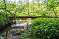
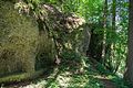
Deutsch: Der Guckerlochfelsen bei Michelfeld ist eine Felswand mit Karsthöhlen im Landkreis Amberg-Sulzbach in der Oberpfalz in Bayern. Er ist als Geotop (371R058), Naturdenkmal und Bodendenkmal (D-3-6235-0004) ausgewiesen.
Geotop in Landkreis Amberg-Sulzbach in Bavaria, Germany  | |||||
| Upload media | |||||
| Instance of | |||||
|---|---|---|---|---|---|
| Location | Auerbach in der Oberpfalz, Amberg-Sulzbach, Upper Palatinate, Bavaria, Germany | ||||
| Heritage designation | |||||
| Width |
| ||||
| Length |
| ||||
| Area |
| ||||
| Elevation above sea level |
| ||||
| official website | |||||
 | |||||
Media in category "Guckerlochfelsen bei Michelfeld"
The following 5 files are in this category, out of 5 total.
-
 2016 Guckerloch 01.jpg 3,456 × 5,184; 4.08 MB
-
 2016 Guckerloch 05.jpg 3,456 × 5,184; 4.19 MB
-
 2016 Guckerloch 06.jpg 5,071 × 3,381; 4.94 MB
-
 2016 Guckerloch 07.jpg 5,085 × 3,390; 5.2 MB
-
 2016 Guckerloch 12.jpg 5,184 × 3,456; 4.23 MB


Categories:
- Natural monuments in Landkreis Amberg-Sulzbach
- Geotopes in Landkreis Amberg-Sulzbach
- Geography in Auerbach in der Oberpfalz
- Michelfeld (Auerbach in der Oberpfalz)
- Cultural heritage monuments in Auerbach in der Oberpfalz
- Rock formations in Landkreis Amberg-Sulzbach
- Geotopes in Naturpark Fränkische Schweiz-Veldensteiner Forst
- Rocks in Naturpark Fränkische Schweiz-Veldensteiner Forst
- Protected areas in Naturpark Fränkische Schweiz-Veldensteiner Forst