Category:Gruyères, occupation gallo-romaine, bourg avec château médiéval-temps modernes
Jump to navigation
Jump to search
| Object location | | View all coordinates using: OpenStreetMap |
|---|
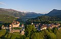
archaeological site in Gruyères in the canton of Fribourg, Switzerland .jpg) Symbolfoto Marktflecken Greyerz mit Schloss | |||||
| Upload media | |||||
| Instance of | |||||
|---|---|---|---|---|---|
| Part of | |||||
| Location | Gruyères, Gruyère District, Canton of Fribourg, Switzerland | ||||
| Street address |
| ||||
| Heritage designation |
| ||||
 | |||||
Media in category "Gruyères, occupation gallo-romaine, bourg avec château médiéval-temps modernes"
This category contains only the following file.
-
 Gruyeres 013 (35250798865).jpg 3,747 × 2,401; 6.24 MB