Category:Grunow-Dammendorf
Jump to navigation
Jump to search
municipality in Landkreis Oder-Spree, Germany    | |||||
| Upload media | |||||
| Instance of |
| ||||
|---|---|---|---|---|---|
| Location | Oder-Spree District, Brandenburg, Germany | ||||
| Population |
| ||||
| Area |
| ||||
| Elevation above sea level |
| ||||
| official website | |||||
 | |||||
Subcategories
This category has the following 4 subcategories, out of 4 total.
C
D
G
Media in category "Grunow-Dammendorf"
The following 8 files are in this category, out of 8 total.
-
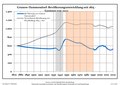 Bevölkerungsentwicklung Grunow-Dammendorf.pdf 1,752 × 1,239; 121 KB
-
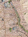
 Dammendorf Dammendorfer Försterei Ziegelei Messtischblatt 3852-1896.jpg 1,129 × 919; 361 KB
-
 Forsthaus Jakobsee Bremsdorfer Mühle Messtischblatt 3852-1896.jpg 646 × 856; 230 KB
-
 Forsthaus Jakobsee Bremsdorfer Mühle Urmesstischblatt 3852-1846.jpg 870 × 1,143; 680 KB
-
 Walkemuehle Oelse Bruecke.JPG 3,648 × 2,736; 2.41 MB
-
 Walkemuehle Oelse.JPG 2,736 × 3,648; 2.42 MB
-
 Wappen Grunow-Dammendorf.png 582 × 647; 47 KB
-
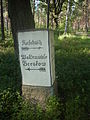 Wegestein Walkemuehle.JPG 2,736 × 3,648; 2.42 MB


