Category:Grube Nordfeld
Jump to navigation
Jump to search
mine in Germany  | |||||
| Upload media | |||||
| Instance of | |||||
|---|---|---|---|---|---|
| Location |
| ||||
| Heritage designation | |||||
 | |||||
Deutsch: Die Steinkohlengrube Nordfeld bestand zwischen 1889 und 1905 am nördlichen Abhang des Höcherberges auf dem Bann des saarländischen Ortes Höchen zwischen den Orten Höchen, Waldmohr und Dunzweiler.
Media in category "Grube Nordfeld"
The following 12 files are in this category, out of 12 total.
-
 Aushangtafel Grube Nordfeld 2.JPG 1,536 × 2,048; 784 KB
-
 Aushangtafel Grube Nordfeld.JPG 2,048 × 1,536; 832 KB
-
 Fortunaschacht.jpg 1,728 × 1,296; 932 KB
-
 Fördermaschinenhaus Fortunaschacht.jpg 1,728 × 1,296; 1.47 MB
-
 Fördermaschinenhaus Nordfeld.jpg 1,296 × 1,728; 1.29 MB
-
 Grubenbahnhof Nordfeld.jpg 1,728 × 1,296; 1.45 MB
-
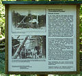 Infotafel Fortunaschacht.jpg 1,294 × 1,202; 726 KB
-
 Maschinenhaus Nordfeld.jpg 1,728 × 1,296; 1.72 MB
-
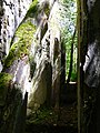
 Ruinen Betriebsgebäude Stollen Nordfeld.jpg 864 × 648; 382 KB
-
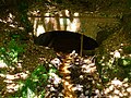 Stollen Nordfeld.jpg 864 × 648; 422 KB
-
 Verladewand.jpg 460 × 281; 14 KB
-
 Wilhelmineschacht.jpg 1,728 × 1,296; 1.87 MB


