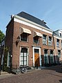
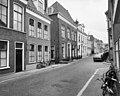
Category:Grote Kerkstraat 39, Leeuwarden
Jump to navigation
Jump to search
| Object location | | View all coordinates using: OpenStreetMap |
|---|
house in Leeuwarden, Netherlands  | |||||
| Upload media | |||||
| Instance of | |||||
|---|---|---|---|---|---|
| Location | Leeuwarden, Friesland, Netherlands | ||||
| Heritage designation |
| ||||
 | |||||
|
This is a category about rijksmonument number 24187
|
| Address |
|
Media in category "Grote Kerkstraat 39, Leeuwarden"
The following 5 files are in this category, out of 5 total.
-
 Exterieur - Leeuwarden - 20132507 - RCE.jpg 1,200 × 952; 315 KB
-
 Gevel - Leeuwarden - 20132508 - RCE.jpg 966 × 1,200; 296 KB
-
 Leeuwarden - Grote Kerkstraat 39 - Van Haersoltehuys.jpg 3,000 × 4,000; 4.11 MB
-
 Voorgevel - Leeuwarden - 20132505 - RCE.jpg 800 × 1,200; 217 KB
-
 Voorgevels - Leeuwarden - 20132509 - RCE.jpg 1,200 × 962; 282 KB


