Category:Grote Kerk (Ternaard)
Jump to navigation
Jump to search
| Object location | | View all coordinates using: OpenStreetMap |
|---|
church  | |||||
| Upload media | |||||
| Instance of | |||||
|---|---|---|---|---|---|
| Location | Ternaard, Noardeast-Fryslân, Friesland, Netherlands | ||||
| Street address |
| ||||
| Located on street |
| ||||
| Heritage designation |
| ||||
| Inception |
| ||||
 | |||||
|
This is a category about rijksmonument number 38731
|
| Address |
|
Media in category "Grote Kerk (Ternaard)"
The following 37 files are in this category, out of 37 total.
-
 Avondmaals bank - Ternaard - 20207690 - RCE.jpg 1,200 × 960; 274 KB
-
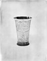 Avondmaalsbeker - Ternaard - 20207696 - RCE.jpg 942 × 1,200; 103 KB
-
 Avondmaalsbeker 1650 - Ternaard - 20207695 - RCE.jpg 950 × 1,200; 121 KB
-
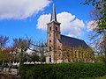
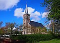 De Kerk van Ternaard.JPG 4,419 × 3,193; 2.43 MB
-
 Detail raam vierde trav‚e zuidzijde - Ternaard - 20207710 - RCE.jpg 1,188 × 1,200; 372 KB
-
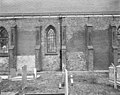 Exterieur gedeelte noordwand - Ternaard - 20207683 - RCE.jpg 1,200 × 948; 396 KB
-
 Exterieur gedeelte noordwand - Ternaard - 20207684 - RCE.jpg 1,200 × 944; 388 KB
-
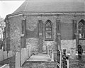
 Exterieur noord-oostgevel - Ternaard - 20207681 - RCE.jpg 1,200 × 960; 382 KB
-
 Exterieur noordwand - Ternaard - 20207682 - RCE.jpg 1,200 × 960; 345 KB
-
 Herenbank - Ternaard - 20207691 - RCE.jpg 960 × 1,200; 252 KB
-
 Hervormde kerk, Tsjerkestrjitte 1, Ternaard.JPG 4,608 × 3,456; 3.21 MB
-
 Interieur naar het westen - Ternaard - 20207685 - RCE.jpg 960 × 1,200; 231 KB
-
 Interieur naar het westen - Ternaard - 20207686 - RCE.jpg 965 × 1,200; 235 KB
-
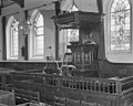
 INTERIEUR, PREEKSTOEL EN DOOPHEK - Ternaard - 20265193 - RCE.jpg 1,200 × 777; 138 KB
-
 Kaarsenarm preekstoel - Ternaard - 20207688 - RCE.jpg 1,200 × 948; 156 KB
-

-
 Kerk Ternaard.jpg 2,440 × 3,648; 1.02 MB
-
 Lezenaar en doopboog - Ternaard - 20207689 - RCE.jpg 1,200 × 961; 185 KB
-
 Orgel, borstwerkdeurtjes van verdwenen borstwerk - Ternaard - 20207705 - RCE.jpg 1,197 × 1,200; 340 KB
-
 Orgel, detail onderkas en band - Ternaard - 20207704 - RCE.jpg 1,200 × 1,200; 282 KB
-
 Orgel, detail onderzijde rugwerk - Ternaard - 20207703 - RCE.jpg 1,195 × 1,200; 358 KB
-
 Orgel, onderzijde rugwerk - Ternaard - 20207702 - RCE.jpg 1,197 × 1,200; 306 KB
-
 Orgel, rugwerkfront - Ternaard - 20207701 - RCE.jpg 958 × 1,200; 253 KB
-
 Orgelbalkon noordzijde - Ternaard - 20207693 - RCE.jpg 1,200 × 960; 233 KB
-
 Orgelbalkon zuidzijde - Ternaard - 20207692 - RCE.jpg 1,200 × 960; 272 KB
-
 Orgelfront - Ternaard - 20207699 - RCE.jpg 954 × 1,200; 225 KB
-
 Orgelfront - Ternaard - 20207700 - RCE.jpg 965 × 1,200; 241 KB
-
 Overzicht zuidwestgevel met kerktoren en kerkhof - Ternaard - 20345966 - RCE.jpg 934 × 1,200; 236 KB
-
 Preekstoel - Ternaard - 20207687 - RCE.jpg 1,200 × 960; 219 KB
-
 Sleutelstuk achter orgelbalkon - Ternaard - 20207694 - RCE.jpg 962 × 1,200; 275 KB
-
 Sleutelstuk onder westelijke trekbalk - Ternaard - 20207706 - RCE.jpg 1,200 × 788; 180 KB
-
 Sleutelstuk onder westelijke trekbalk - Ternaard - 20207707 - RCE.jpg 1,200 × 798; 152 KB
-
 Ternaard tsjerke.JPG 1,536 × 2,048; 962 KB
-
 Tinnen wijnkan - Ternaard - 20207697 - RCE.jpg 948 × 1,200; 106 KB
-

-
 Zerk voor Ernst van Aylva - Ternaard - 20207698 - RCE.jpg 952 × 1,200; 351 KB
-
 Zuid-oostgevel - Ternaard - 20207680 - RCE.jpg 1,200 × 960; 328 KB


