Category:Grote Kerk, Hoorn (1369-1838)
Jump to navigation
Jump to search
| Camera location | | View all coordinates using: OpenStreetMap |
|---|
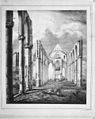
Nederlands: Dit was een grote, historische kerk met toren, die in 1369 werd gebouwd als R.K. kerk. Door brand verwoest op 3 augustus 1838.
Media in category "Grote Kerk, Hoorn (1369-1838)"
The following 20 files are in this category, out of 20 total.
-

-

-

-

-

-

-
 Interieur detail door Gerrit Uit den Ruygen 1695 - Hoorn - 20115908 - RCE.jpg 1,200 × 953; 262 KB
-
-

-

-

-

-

-
 Plattegrond tekening - Hoorn - 20115893 - RCE.jpg 1,200 × 959; 229 KB
-

-

-

-

-

-
 Uitvergroting plattegrond P. ten Waes - Hoorn - 20115935 - RCE.jpg 881 × 1,200; 357 KB


