Category:Grote Hoogstraat 44, Leeuwarden
Jump to navigation
Jump to search
| Object location | | View all coordinates using: OpenStreetMap |
|---|
building in Leeuwarden, Netherlands  | |||||
| Upload media | |||||
| Instance of | |||||
|---|---|---|---|---|---|
| Location | Leeuwarden, Friesland, Netherlands | ||||
| Located on street | |||||
| Heritage designation |
| ||||
 | |||||
|
This is a category about rijksmonument number 24174
|
| Address |
|
Media in category "Grote Hoogstraat 44, Leeuwarden"
The following 4 files are in this category, out of 4 total.
-
 Achtergevel - Leeuwarden - 20132425 - RCE.jpg 801 × 1,200; 197 KB
-
 Overzicht Grote Hoogstraat - Leeuwarden - 20130521 - RCE.jpg 1,181 × 1,200; 278 KB
-
 Voorgevel - Leeuwarden - 20132424 - RCE.jpg 807 × 1,200; 193 KB
-
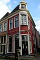 WLM - 23dingenvoormusea - Repelsteeltje restaurant, Leeuwarden.jpg 798 × 1,200; 398 KB


