Category:Grinsel 1, Den Dungen
Jump to navigation
Jump to search
| Object location | | View all coordinates using: OpenStreetMap |
|---|
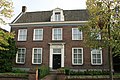
house in Sint-Michielsgestel, Netherlands  | |||||
| Upload media | |||||
| Instance of | |||||
|---|---|---|---|---|---|
| Location | Den Dungen, North Brabant, Netherlands | ||||
| Street address |
| ||||
| Located on street |
| ||||
| Heritage designation |
| ||||
 | |||||
|
This is a category about rijksmonument number 14189
|
| Address |
|
Media in category "Grinsel 1, Den Dungen"
The following 4 files are in this category, out of 4 total.
-
 Den Dungen - Grinsel 1 - Dorpswoning (1).jpg 1,650 × 2,473; 2.55 MB
-
 Den Dungen - Grinsel 1 - Dorpswoning.jpg 3,888 × 2,592; 7 MB
-
 R.K.Pastorie - Den Dungen - 20065193 - RCE.jpg 1,200 × 942; 294 KB
-
 Voorgevels - Den Dungen - 20065194 - RCE.jpg 1,200 × 945; 304 KB
.jpg)

