Category:Greystone Bridge
Jump to navigation
Jump to search
| Object location | | View all coordinates using: OpenStreetMap |
|---|
bridge over the River Tamar  | |||||
| Upload media | |||||
| Instance of | |||||
|---|---|---|---|---|---|
| Location | |||||
| Crosses | |||||
| Heritage designation |
| ||||
 | |||||
Media in category "Greystone Bridge"
The following 2 files are in this category, out of 2 total.
-
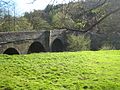 The Greystone Bridge - geograph-1854319.jpg 640 × 480; 133 KB
-
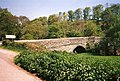 Lezant, Greystone Bridge - geograph.org.uk - 39087.jpg 640 × 434; 172 KB

Categories:
- 1430s architecture in England
- 1430s bridges in the United Kingdom
- 15th-century architecture in Cornwall
- 15th-century architecture in Devon
- Bradstone
- Bridges over the River Tamar
- Bridges completed in 1439
- Built in England in 1439
- Grade I listed bridges in Cornwall
- Grade I listed bridges in Devon
- Lezant
- Road bridges in Cornwall
- Road bridges in Devon
- Stone arch bridges in Cornwall
- Stone arch bridges in Devon
- Tamar Valley Discovery Trail
- B3362 road (England)