Category:Green Lane Jewish Cemetery, Liverpool
Jump to navigation
Jump to search
| Object location | | View all coordinates using: OpenStreetMap |
|---|
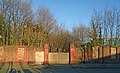
The walls and gate piers are the only visible remnants of the Jewish Cemetery on Green Lane, Stoneycroft, Liverpool. It was established in 1839 and used until 1921. The plot is now overgrown although it was surveyed in 1979.
Media in category "Green Lane Jewish Cemetery, Liverpool"
The following 2 files are in this category, out of 2 total.
-
 Benchmark at Jewish cemetery, Stoneycroft.jpg 4,524 × 3,200; 10 MB
-
 Jewish Cemetery, Green Lane.jpg 4,958 × 3,011; 9.45 MB

