Category:Great and Little Kimble cum Marsh
Jump to navigation
Jump to search
English: The Kimbles are a group of English village to the south of Aylesbury in the county of Buckinghamshire, sitting at the foot of the Chiltern Hills. The three villages are called Great Kimble, Little Kimble and Kimble Wick. The three villages are respectively named after "The Greater village of Cymbeline", "The Lesser village of Cymbeline", and "Cymbeline's farm". Great and Little Kimble cum Marsh is also the name of a civil parish within Wycombe district.

civil parish in Buckinghamshire, England  | |||||
| Upload media | |||||
| Instance of | |||||
|---|---|---|---|---|---|
| Location | Buckinghamshire, South East England, England | ||||
| Population |
| ||||
 | |||||
Subcategories
This category has the following 4 subcategories, out of 4 total.
Media in category "Great and Little Kimble cum Marsh"
The following 134 files are in this category, out of 134 total.
-
 A mystery building in Kimblewick Road - geograph.org.uk - 94031.jpg 640 × 480; 101 KB
-
 A Narrow Footbridge - geograph.org.uk - 4769160.jpg 4,000 × 2,664; 5.73 MB
-
 Airstrip near Marsh, aerial - geograph.org.uk - 3478261.jpg 640 × 427; 56 KB
-
 Aylesbury Road leaving Askett - geograph.org.uk - 3890973.jpg 1,500 × 999; 133 KB
-
 Barn and Shed by the Footpath - geograph.org.uk - 4976278.jpg 1,600 × 1,124; 438 KB
-
 Beacon Hill from the lower slopes of Pulpit Hill - geograph.org.uk - 2743501.jpg 3,968 × 2,976; 3.16 MB
-
 Blossom by the Aylesbury Ring - geograph.org.uk - 4476471.jpg 3,736 × 2,944; 2.8 MB
-
 Bridleway to Marsh Crossing - geograph.org.uk - 1155813.jpg 640 × 480; 122 KB
-
 Bridleway, Pulpit Hill - geograph.org.uk - 6384035.jpg 1,024 × 768; 512 KB
-
 By the North Bucks Way - geograph.org.uk - 4984648.jpg 1,600 × 1,223; 594 KB
-
 Clematis Cottage - geograph.org.uk - 181258.jpg 640 × 480; 94 KB
-
 Cloudy Sky and Cricket Nets - geograph.org.uk - 4748846.jpg 3,596 × 2,392; 2.88 MB
-
 Cradle footpath, looking eastwards - geograph.org.uk - 5682078.jpg 5,202 × 3,465; 4.5 MB
-
 Earthwork, Great Kimble - geograph.org.uk - 5648737.jpg 3,888 × 2,592; 3.46 MB
-
 Earthworks at Great Kimble - geograph.org.uk - 5648733.jpg 3,888 × 2,592; 3.5 MB
-
 Entrance to Pulpit Wood - geograph.org.uk - 3902973.jpg 4,320 × 3,240; 6.4 MB
-
 Farmland, Kimble - geograph.org.uk - 2233518.jpg 640 × 480; 125 KB
-
 Farmland, Kimble - geograph.org.uk - 4382140.jpg 640 × 480; 199 KB
-
 Farmland, Kimble - geograph.org.uk - 4382177.jpg 640 × 480; 226 KB
-
 Farmland, Kimble - geograph.org.uk - 4382374.jpg 640 × 427; 216 KB
-
 Fence around the Fort - geograph.org.uk - 5650299.jpg 1,600 × 1,067; 936 KB
-
 Field off Kimblewick Road - geograph.org.uk - 1155706.jpg 640 × 480; 54 KB
-
 Fields and Trees, Kimble Wick - geograph.org.uk - 4977564.jpg 1,600 × 1,200; 675 KB
-
 Fields near Kimble Wick - geograph.org.uk - 53679.jpg 640 × 480; 104 KB
-
 Fish Pond, Great Kimble - geograph.org.uk - 5648745.jpg 3,888 × 2,592; 3.2 MB
-
 Footpath Entrance in Pulpit Wood - geograph.org.uk - 5650314.jpg 2,592 × 3,398; 3.74 MB
-
 Footpath Entrance near Kimble Wick - geograph.org.uk - 4984659.jpg 4,000 × 3,000; 3.73 MB
-
 Footpath in Whorley Wood - geograph.org.uk - 2158581.jpg 640 × 480; 130 KB
-
 Footpath off Kimblewick Road - geograph.org.uk - 1155730.jpg 640 × 480; 36 KB
-
 Footpath off Kimblewick Road - geograph.org.uk - 4501599.jpg 1,600 × 1,200; 506 KB
-
 Footpath to Apsley Manor Farm - geograph.org.uk - 1229275.jpg 640 × 480; 103 KB
-
 Footpath to Hill View Farm - geograph.org.uk - 1155714.jpg 640 × 480; 94 KB
-
 Footpath to Kimblewick - geograph.org.uk - 1155765.jpg 640 × 480; 77 KB
-
 Former KX300 Telephone Kiosk at Little Kimble - geograph.org.uk - 5273420.jpg 2,592 × 1,944; 1.36 MB
-
 Former KX300 Telephone Kiosk at Smokey Row - geograph.org.uk - 5273398.jpg 2,592 × 1,944; 1.34 MB
-
 Gate to Cradle footpath - geograph.org.uk - 5682073.jpg 5,202 × 3,465; 5.88 MB
-
 Gate to footpath over Chequers Knap - geograph.org.uk - 5681398.jpg 5,202 × 3,465; 4.31 MB
-
 Grangelands Nature Reserve - geograph.org.uk - 5649509.jpg 1,024 × 683; 234 KB
-
 Grazing horses - geograph.org.uk - 6384131.jpg 1,024 × 768; 305 KB
-
 Great Kimble - Footpath - geograph.org.uk - 5275083.jpg 2,560 × 1,920; 2.9 MB
-
 Great Kimble - St Nicholas - "Aylesbury" font - side - geograph.org.uk - 4020645.jpg 1,000 × 1,333; 1.01 MB
-
 Great Kimble - St Nicholas - "Aylesbury" font in situ - geograph.org.uk - 4020638.jpg 1,000 × 1,407; 1.02 MB
-
 Great Kimble - St Nicholas - "East" window in chancel - geograph.org.uk - 4020677.jpg 1,000 × 1,306; 1.14 MB
-
 Great Kimble - St Nicholas - Ancient Parish Chest (1) - geograph.org.uk - 4020667.jpg 1,291 × 1,000; 956 KB
-
 Great Kimble - St Nicholas - Ancient Parish Chest (2) - geograph.org.uk - 4020670.jpg 1,533 × 1,000; 1.16 MB
-
 Great Kimble - St Nicholas - Chancel end - geograph.org.uk - 4020632.jpg 1,441 × 1,000; 1.03 MB
-
 Great Kimble - St Nicholas - Churchyard from the verge - geograph.org.uk - 4020623.jpg 1,333 × 1,000; 1.19 MB
-
 Great Kimble - St Nicholas - Font - base carving - geograph.org.uk - 4020659.jpg 1,536 × 1,000; 1.14 MB
-
 Great Kimble - St Nicholas - Font - bowl fluting - geograph.org.uk - 4020654.jpg 1,522 × 1,000; 1.05 MB
-
 Great Kimble - St Nicholas - Font - rim carving detail - geograph.org.uk - 4020649.jpg 1,333 × 1,000; 1.03 MB
-
 Great Kimble - St Nicholas - Norman font with flowers - geograph.org.uk - 4020641.jpg 1,000 × 1,030; 902 KB
-
 Great Kimble - St Nicholas - Northwestern façade - geograph.org.uk - 4020631.jpg 1,412 × 1,000; 1.14 MB
-
 Great Kimble - St Nicholas - Signboard (north) - geograph.org.uk - 4020636.jpg 1,000 × 1,267; 1.04 MB
-
 Great Kimble - St Nicholas - Signboard (south) - geograph.org.uk - 4020633.jpg 1,000 × 1,212; 895 KB
-
 Great Kimble - St Nicholas - Southeastern façade - geograph.org.uk - 4020629.jpg 1,457 × 1,000; 1.19 MB
-
 Great Kimble - St Nicholas - Stained glass window - geograph.org.uk - 4020682.jpg 1,000 × 1,450; 1.12 MB
-
 Green Lane - geograph.org.uk - 262467.jpg 480 × 640; 499 KB
-
 Hay barn, Kimble Wick - geograph.org.uk - 46685.jpg 640 × 480; 108 KB
-
 Hobbit Way Cadsden - geograph.org.uk - 1471128.jpg 640 × 426; 97 KB
-
 Houses at Kimble Wick - geograph.org.uk - 46679.jpg 640 × 480; 111 KB
-
 Houses, Clanking - geograph.org.uk - 4748839.jpg 3,734 × 2,225; 2.68 MB
-
 Is this path ever used^ - geograph.org.uk - 4976399.jpg 1,600 × 1,200; 554 KB
-
 Kimble Stewart Hall - geograph.org.uk - 2968029.jpg 1,024 × 676; 136 KB
-
 Kimblewick Farm - geograph.org.uk - 181273.jpg 640 × 480; 97 KB
-
 Kimblewick Road - geograph.org.uk - 1155779.jpg 640 × 480; 75 KB
-
 Kimblewick Road - geograph.org.uk - 181277.jpg 640 × 480; 109 KB
-
 Lane from Great Kimble past Rifle Range Farm - geograph.org.uk - 5681388.jpg 5,202 × 3,465; 3.29 MB
-
 Lane past Great Kimble warren to Aylesbury Road - geograph.org.uk - 5681394.jpg 5,202 × 3,465; 4.48 MB
-
 Leaping Lorries - geograph.org.uk - 4748853.jpg 3,596 × 2,500; 2.93 MB
-
 Little Kimble Free Church - geograph.org.uk - 4231387.jpg 4,320 × 3,240; 4.86 MB
-
 Little Kimble railway station - geograph.org.uk - 3335757.jpg 1,024 × 768; 202 KB
-
 Little Kimble Station - geograph.org.uk - 2978973.jpg 1,600 × 1,045; 427 KB
-
 Little Kimble station building - geograph.org.uk - 5681333.jpg 4,124 × 3,005; 2.09 MB
-
 Little Kimble Warren - geograph.org.uk - 5275089.jpg 2,560 × 1,920; 3.29 MB
-
 Little Kimble, looking towards Aylesbury - geograph.org.uk - 5681330.jpg 5,202 × 3,465; 4.07 MB
-
 Longdown Hill, Cadsden - geograph.org.uk - 5738853.jpg 2,020 × 1,498; 1.5 MB
-
 Mud in Pulpit Wood - geograph.org.uk - 5649516.jpg 1,600 × 1,067; 922 KB
-
 Mystery building , Close up - geograph.org.uk - 162792.jpg 480 × 640; 105 KB
-
 National Trust Notice and Sign at Pulpit Wood, Bucks - geograph.org.uk - 5879713.jpg 2,592 × 1,944; 1.32 MB
-
 National Trust Notice at Pulpit Wood - geograph.org.uk - 5879702.jpg 1,944 × 2,592; 952 KB
-
 North Buckinghamshire Way near Kimble Wick - geograph.org.uk - 53694.jpg 480 × 640; 157 KB
-
 North Bucks Way east of Kimble Wick - geograph.org.uk - 4984647.jpg 1,600 × 1,200; 716 KB
-
 North Bucks Way, Kimble Wick - geograph.org.uk - 4976265.jpg 1,600 × 1,200; 558 KB
-
 North Bucks Way, looking north towards Great Kimble - geograph.org.uk - 5682077.jpg 5,202 × 3,465; 6.48 MB
-
 Outer Aylesbury Ring - geograph.org.uk - 5275085.jpg 1,317 × 2,560; 1.84 MB
-
 Outside Little Kimble Station - geograph.org.uk - 2968024.jpg 800 × 484; 140 KB
-
 Parish Notices, Bridge Street - geograph.org.uk - 4476460.jpg 4,000 × 3,000; 2.5 MB
-
 Pasture, Kimble - geograph.org.uk - 4382121.jpg 640 × 480; 185 KB
-
 Pasture, Kimble - geograph.org.uk - 4382227.jpg 640 × 480; 215 KB
-
 Pasture, Kimble - geograph.org.uk - 4382303.jpg 640 × 480; 217 KB
-
 Pasture, Kimble - geograph.org.uk - 4383463.jpg 640 × 480; 229 KB
-
 Pasture, Kimble - geograph.org.uk - 6771278.jpg 1,024 × 683; 243 KB
-
 Pasture, Kimble - geograph.org.uk - 6771280.jpg 1,024 × 683; 217 KB
-
 Pasture, Kimble - geograph.org.uk - 6771287.jpg 1,024 × 683; 217 KB
-
 Path leading up Pulpit Hill - geograph.org.uk - 2743492.jpg 3,968 × 2,976; 3.17 MB
-
 Path to Pulpit Hill Fort - geograph.org.uk - 5650288.jpg 3,888 × 2,592; 4.27 MB
-
 Path towards Beacon Hill - geograph.org.uk - 5682082.jpg 5,202 × 3,465; 2.91 MB
-
 Path up to Pulpit Hill Fort - geograph.org.uk - 6384040.jpg 1,024 × 768; 500 KB
-
 Paths, Pulpit Wood - geograph.org.uk - 4403003.jpg 640 × 480; 183 KB
-
 Poplar Farm, Kimble Wick - geograph.org.uk - 46681.jpg 640 × 480; 149 KB
-
 Pulpit Wood on part of the Icknield Way - geograph.org.uk - 2742020.jpg 3,968 × 2,976; 2.7 MB
-
 R.A.F. Halton aerodrome, aerial - geograph.org.uk - 3478272.jpg 640 × 427; 81 KB
-
 Riding past the Mystery Building - geograph.org.uk - 4501586.jpg 1,600 × 1,186; 380 KB
-
 Road or Bridleway^ Kimble Wick - geograph.org.uk - 53688.jpg 640 × 480; 125 KB
-
 Rose hips in December on the lower slopes of Pulpit Hill - geograph.org.uk - 2743495.jpg 3,968 × 2,976; 2.8 MB
-
 Roundhill Farm - geograph.org.uk - 160657.jpg 640 × 480; 112 KB
-
 Scrub and paddocks, Kimble - geograph.org.uk - 2233537.jpg 640 × 480; 127 KB
-

-
 Shed near Marsh Hill Farm - geograph.org.uk - 4976164.jpg 1,600 × 1,120; 495 KB
-
 St Nicholas church, Great Kimble - geograph.org.uk - 5681384.jpg 5,202 × 3,465; 4.03 MB
-
 St Nicholas, Great Kimble - Altar - geograph.org.uk - 3266003.jpg 701 × 1,000; 300 KB
-
 St Nicholas, Great Kimble - Font - geograph.org.uk - 3266005.jpg 769 × 1,000; 210 KB
-
 St Nicholas, Great Kimble - geograph.org.uk - 3266000.jpg 1,000 × 731; 242 KB
-
 Strange Tree in Pulpit Wood - geograph.org.uk - 5649576.jpg 3,333 × 2,093; 3.31 MB
-
 Study in Green - geograph.org.uk - 184966.jpg 480 × 640; 160 KB
-
 The Bernard Arms - geograph.org.uk - 5882607.jpg 1,080 × 810; 123 KB
-
 The Bernard Arms, Great Kimble - geograph.org.uk - 5681337.jpg 5,202 × 3,465; 2.64 MB
-
 The entrance to Pulpit Wood, Cadsden - geograph.org.uk - 5738830.jpg 2,048 × 1,536; 1.48 MB
-
 The Line to Aylesbury - geograph.org.uk - 4748865.jpg 4,000 × 2,664; 2.69 MB
-
 The Prince of Wales, Marsh - geograph.org.uk - 162788.jpg 640 × 478; 106 KB
-
 The Ridgeway - geograph.org.uk - 5275078.jpg 2,560 × 1,920; 2.55 MB
-
 The Swan pub, Smokey Row - geograph.org.uk - 4231390.jpg 4,320 × 3,240; 4.33 MB
-
 Trees on Pulpit Hill - geograph.org.uk - 2743499.jpg 3,968 × 2,976; 3.15 MB
-
 Unused farm buildings, Roundhill - geograph.org.uk - 162787.jpg 640 × 480; 98 KB
-
 Upper Icknield Way - geograph.org.uk - 1051868.jpg 640 × 480; 122 KB
-
 Vale Farm - geograph.org.uk - 160655.jpg 640 × 480; 139 KB
-
 View across Great Kimble Warren - geograph.org.uk - 181446.jpg 640 × 480; 100 KB
-
 View from North Bucks way towards Whiteleaf Hill - geograph.org.uk - 5682067.jpg 5,202 × 3,465; 3 MB
-
 View towards Grange Farm from North Bucks Way - geograph.org.uk - 5682069.jpg 5,202 × 3,465; 3.58 MB
-
 View towards Pulpit Hill from North Bucks Way - geograph.org.uk - 5682071.jpg 5,202 × 3,465; 6.13 MB
-
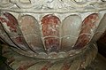
 Wall-painting at Little Kimble, St George - geograph.org.uk - 5044183.jpg 704 × 1,024; 129 KB
-
 Whiteleaf Hill from near to Pulpit Hill - geograph.org.uk - 2743498.jpg 3,968 × 2,976; 2.76 MB
-
 Wooded hilltop, Kimble - geograph.org.uk - 2233544.jpg 640 × 480; 127 KB
-


_-_geograph.org.uk_-_4020667.jpg)
_-_geograph.org.uk_-_4020670.jpg)


_-_geograph.org.uk_-_4020636.jpg)
_-_geograph.org.uk_-_4020633.jpg)


,_Little_Kimble_church_-_geograph.org.uk_-_5045211.jpg)


