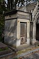
Category:Grave of Mader (Père-Lachaise, division 52)
Jump to navigation
Jump to search
| Grave of Mader (Père-Lachaise, division 52) | |||||||||||||||||||||||||
|---|---|---|---|---|---|---|---|---|---|---|---|---|---|---|---|---|---|---|---|---|---|---|---|---|---|
| |||||||||||||||||||||||||

sepulchral chapel located in Paris, in France  | |||||
| Upload media | |||||
| Instance of | |||||
|---|---|---|---|---|---|
| Location | Père-Lachaise Cemetery - Division 52, Quartier du Père-Lachaise, 20th arrondissement of Paris, Paris, Grand Paris, France | ||||
| Collection | |||||
 | |||||
Media in category "Grave of Mader (Père-Lachaise, division 52)"
The following 5 files are in this category, out of 5 total.
-
 Père-Lachaise - Division 52 - Mader 01.jpg 4,929 × 3,286; 12.65 MB
-
 Père-Lachaise - Division 52 - Mader 02.jpg 5,184 × 3,456; 16.95 MB
-
 Père-Lachaise - Division 52 - Mader 03.jpg 5,184 × 3,456; 15.19 MB
-
 Père-Lachaise - Division 52 - Mader 04.jpg 5,184 × 3,456; 13.66 MB
-
 Père-Lachaise - Division 52 - Mader 05.jpg 3,456 × 5,184; 10.79 MB


