Category:Grave of Kaya (Père-Lachaise, division 71)
Jump to navigation
Jump to search

|
These works or works by this artist may not be in the public domain, because the artist is still living or has not been dead for at least 70 years. Please do not upload photographs or scans of works by this artist, unless they meet one of the following exceptions:
|
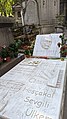
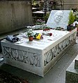
| Grave of Kaya
|
||||
|---|---|---|---|---|
| Artist |
Unknown author |
 | ||
| Title |
Grave of Ahmet Kaya |
|||
| Object type | grave | |||
| Genre |
funerary art |
|||
| Description |
Français : Tombe du chanteur kurde Ahmet Kaya (1957-2000) |
|||
| Collection | ||||
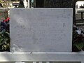
| Current location |
Division 71, section 2, avenue circulaire, line 1, Mairie de Paris: 1/72 5/69 Tomb on the left : Goiset, on the right : Thomas-Vayssière |
|||
| Object location |
|
|||
| Inscriptions |
Kızı Melis ve Eşi Gülten tarafindan; Onlara bıraktığı onurun gücüyle yaptirilmiştir... 16.11.2003
[From his daughter Melis and his wife Gülten; Made with power of honor he left for them... 16.11.2003] |
|||

| Object location | | View all coordinates using: OpenStreetMap |
|---|
| |||||
| Upload media | |||||
| Instance of | |||||
|---|---|---|---|---|---|
| Genre | |||||
| Location | Père-Lachaise Cemetery - Division 71, Quartier du Père-Lachaise, 20th arrondissement of Paris, Paris, Grand Paris, France | ||||
| Collection | |||||
 | |||||
Media in category "Grave of Kaya (Père-Lachaise, division 71)"
The following 7 files are in this category, out of 7 total.
-
 Ahmet Kaya Grave.jpg 2,268 × 4,032; 2.51 MB
-
 Ahmet Kaya tombe 2024.jpg 3,072 × 4,080; 6.59 MB
-
 Ahmet Kaya tombe.jpg 3,120 × 4,160; 3.29 MB
-
 Le pierre tombale de Ahmet Kaya dans le Cimetière du Père-Lachaise 3.JPG 1,360 × 1,020; 657 KB
-
 Le pierre tombale de Ahmet Kaya dans le Cimetière du Père-Lachaise 4.JPG 1,020 × 1,360; 557 KB
-
 Pere Lachaise Ahmet kaya Yüz.JPG 1,360 × 1,020; 694 KB
-
 Tombe Ahmet Kaya.jpg 1,624 × 1,740; 875 KB


