Category:Granger Mountain (Utah)
Jump to navigation
Jump to search
mountain in Utah County, Utah, United States | |||||
| Upload media | |||||
| Instance of | |||||
|---|---|---|---|---|---|
| Located in protected area | |||||
| Location | Utah County, Utah | ||||
| Mountain range | |||||
| Topographic prominence |
| ||||
 | |||||
English: Media related to Granger Mountain (Utah), a 8,002-foot (2,439 m) mountain in the Uinta-Wasatch-Cache National Forest in the southern Wasatch Range (east of Springville) in Utah County, Utah, United States, that divides Hobble Creek Canyon (and Hobble Creek) into the left and right forks.
Media in category "Granger Mountain (Utah)"
The following 4 files are in this category, out of 4 total.
-
 Bartholomew Hydroelectic Project, Sep 16.jpg 2,592 × 1,944; 2.26 MB
-
 Camp Jeremiah Johnson parking entrance, Hobble Creek Canyon, Sep 16.jpg 2,592 × 1,944; 2.34 MB
-
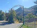
 Camp Jeremiah Johnson sign, Hobble Creek Canyon, Sep 16.jpg 2,592 × 1,944; 2.15 MB
-
 Shooting area, Right Fork Hobble Creek Canyon, Utah County, Utah, Jul 16.jpg 2,592 × 1,944; 2.26 MB


