Category:Grand Trunk Pacific Dock fire
Jump to navigation
Jump to search
| Object location | | View all coordinates using: OpenStreetMap |
|---|
Media in category "Grand Trunk Pacific Dock fire"
The following 17 files are in this category, out of 17 total.
-

-

-

-

-
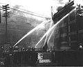
 Grand Trunk Dock fire, Seattle, July 30, 1914 (MOHAI 1135).jpg 640 × 488; 49 KB
-
 Grand Trunk Dock fire, Seattle, July 30, 1914 (MOHAI 729).jpg 640 × 479; 39 KB
-
 Grand Trunk Pacific Dock fire damage, July 30, 1914 (MOHAI 6311).jpg 700 × 539; 51 KB
-

-
-

-

-

-

-
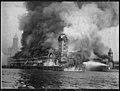 Grand Trunk Pacific dock fire, July 30, 1914 (MOHAI 6215).jpg 926 × 700; 72 KB
-

-

-

.jpg)

.jpg)
.jpg)
.jpg)
.jpg)
.jpg)
.jpeg)
.jpeg)
.jpeg)
.jpeg)
.jpeg)
.jpeg)
.jpg)


