Category:Granary in Racibórz-Sudół
Jump to navigation
Jump to search
| Object location | | View all coordinates using: OpenStreetMap |
|---|
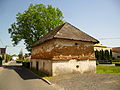
Polski: Drewniano-murowany spichlerz przy domu nr 27, pocz. XIX w. - Racibórz-Sudół, ul. Czynu Społecznego 14
historic building in Racibórz, Silesian Voivodeship, Poland  | |||||
| Upload media | |||||
| Instance of | |||||
|---|---|---|---|---|---|
| Part of | |||||
| Location | Sudół, Racibórz, Racibórz County, Silesian Voivodeship, Poland | ||||
| Street address |
| ||||
| Heritage designation |
| ||||
| Inception |
| ||||
| Elevation above sea level |
| ||||
 | |||||
Media in category "Granary in Racibórz-Sudół"
The following 8 files are in this category, out of 8 total.
-
 Spichlerz Sudol, okres Raćibórz, Slezské vojvodství, Polsko 01.jpg 9,248 × 6,944; 23.65 MB
-
 Spichlerz Sudol, okres Raćibórz, Slezské vojvodství, Polsko 02.jpg 6,944 × 9,248; 42.97 MB
-
 Spichlerz Sudol, okres Raćibórz, Slezské vojvodství, Polsko 03.jpg 9,248 × 6,944; 34.36 MB
-
 Spichlerz Sudol, okres Raćibórz, Slezské vojvodství, Polsko 04.jpg 6,944 × 9,248; 30.14 MB
-
 Spichlerz Sudol, okres Raćibórz, Slezské vojvodství, Polsko 05.jpg 9,248 × 6,944; 23.92 MB
-
 Spichlerz w Raciborzu Sudół.jpg 1,280 × 850; 323 KB
-
 Spichlerz w Sudole 2.JPG 4,000 × 3,000; 5.18 MB
-
 Spichlerz w Sudole.JPG 4,000 × 3,000; 5.18 MB


