Category:Grafrath
Jump to navigation
Jump to search

municipality of Germany    | |||||
| Upload media | |||||
| Instance of |
| ||||
|---|---|---|---|---|---|
| Part of |
| ||||
| Location | Fürstenfeldbruck, Upper Bavaria, Bavaria, Germany | ||||
| Head of government |
| ||||
| Population |
| ||||
| Area |
| ||||
| Elevation above sea level |
| ||||
| official website | |||||
 | |||||
Deutsch: Grafrath ist eine Gemeinde im oberbayerischen Landkreis Fürstenfeldbruck.
Subcategories
This category has the following 7 subcategories, out of 7 total.
Media in category "Grafrath"
The following 7 files are in this category, out of 7 total.
-
 612 011 bei Kottgeisering 2021.jpg 3,636 × 2,700; 8.11 MB
-
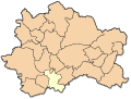 Grafrath in ffb.svg 435 × 330; 103 KB
-
 Grafrath in FFB.svg 446 × 390; 976 KB
-
 Grafrath Wappen.png 378 × 381; 16 KB
-
 Toteisloch Wolfsgrube GO-1.jpg 2,592 × 1,944; 1.71 MB
-
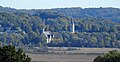 Türkenfeld, FFB - Zankenhausen nördl - Grafrath, FFB v SW, Ampermoos 01.jpg 4,608 × 2,383; 769 KB
-
 Türkenfeld, FFB - Zankenhausen nördl - Kottgeisering, Grafrath, FFB v SW, Ampermoos 01.jpg 4,608 × 2,592; 1.07 MB


