Category:Grade II listed buildings in the Metropolitan Borough of Oldham
Jump to navigation
Jump to search
Subcategories
This category has the following 19 subcategories, out of 19 total.
B
- Booth House, Oldham (2 F)
C
- Chadderton Mill (14 F)
D
- Devon Mill, Hollinwood (9 F)
F
- Former Post Office, Oldham (2 F)
H
- Hartford Mill, Oldham (35 F)
- Hollinwood Cemetery (4 F)
J
- Joseph Howarth Statue (3 F)
M
- Manor Mill, Chadderton (16 F)
- Moravian Sunday School (4 F)
N
- Nile Mill, Chadderton (11 F)
O
- Old Town Hall, Oldham (9 F)
R
- Robert Ascroft Statue (6 F)
S
- Slattocks Top Lock (4 F)
- St Marks Church, Glodwick (3 F)
Media in category "Grade II listed buildings in the Metropolitan Borough of Oldham"
The following 83 files are in this category, out of 83 total.
-
 1-13 New Street.jpg 3,304 × 2,842; 3.06 MB
-
 121 Union Street, Oldham-geograph-3808795.jpg 1,280 × 1,180; 353 KB
-
 13 The Shaws Uppermill.jpg 1,920 × 2,560; 560 KB
-
 2 and 4 Oldham Road, Delph.jpg 3,000 × 4,000; 2.32 MB
-
 2,3,&4 The Shaws Uppermill.jpg 2,372 × 1,400; 766 KB
-
 33-37 Middleton Gardens.jpg 3,564 × 2,154; 1.51 MB
-
 Albion Farm House Delph.jpg 7,360 × 4,912; 21.6 MB
-
 Anchor Mill, Oldham-geograph-1947901.jpg 841 × 1,280; 412 KB
-
 Aqueduct at Lock 23 on Huddersfield Narrow Canal.jpg 2,011 × 2,665; 661 KB
-
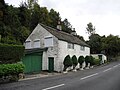
 Ballgrove Cottage.jpg 2,108 × 1,581; 380 KB
-
 Ballgrove.jpg 3,456 × 2,304; 2.89 MB
-
 Blue coat0004.jpg 367 × 253; 31 KB
-
 Bont, Uppermill.jpg 3,456 × 2,304; 4.02 MB
-
 Chadderton Library.jpg 640 × 480; 123 KB
-
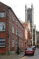 Church Lane, Oldham (geograph 3808737).jpg 854 × 1,280; 341 KB
-
 Cockleshell Cottage, Dobcross.jpg 640 × 480; 80 KB
-
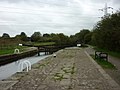 Coneygreen Lock.jpg 800 × 600; 257 KB
-
 Conservatory, Alexandra Park, Oldham.jpg 1,280 × 960; 913 KB
-
 Cottage by Primrose Hill Farmhouse, Pobgree.jpg 3,456 × 2,304; 753 KB
-
 Cottages, Delph.jpg 640 × 489; 116 KB
-
 Cross Keys, Uppermill.jpg 3,456 × 2,304; 755 KB
-
 Delph Bridge.jpg 1,280 × 960; 633 KB
-
 Division Bridge - geograph.org.uk - 592227.jpg 640 × 480; 104 KB
-
 Fairbanks, Diggle (geograph 2395221).jpg 4,162 × 2,917; 3.01 MB
-
 Flash Cottages.jpg 640 × 480; 127 KB
-
 Former bank, Dobcross.jpg 640 × 480; 86 KB
-
 Former board school, Oldham.jpg 640 × 480; 215 KB
-
 Former Cross Keys Inn.jpg 2,867 × 1,926; 3.02 MB
-
 Fountain, Alexandra Park, Oldham.jpg 1,280 × 960; 700 KB
-

-
 Golburn Cottage.jpg 2,537 × 1,903; 584 KB
-
 Hartford Works, Suthers Street, Oldham (geograph 3229357).jpg 640 × 480; 121 KB
-
 Hearse House, Uppermill.jpg 1,800 × 1,200; 237 KB
-
 HeathfieldHouseAndAdjoiningCottage.jpg 2,560 × 1,920; 1.38 MB
-
 High Street, Uppermill.jpg 1,669 × 1,510; 871 KB
-
 Mill & Church - Oldham.jpg 427 × 640; 68 KB
-
 Houses overlooking The Square, Dobcross.jpg 640 × 480; 83 KB
-
 HSBC Bank, Oldham.jpg 1,600 × 1,064; 374 KB
-
 K6 Telephone Kiosk and Bernard Barnes Historian Geographer Scholar.jpg 4,912 × 7,360; 32.09 MB
-
 Knowle Top Farmhouse.jpg 1,873 × 1,405; 259 KB
-
 Ladhill Bridge, Greenfield.jpg 800 × 600; 928 KB
-
 Ladhill Bridge.jpg 3,335 × 2,648; 3.6 MB
-
 Lane End Farm.jpg 3,610 × 2,480; 3.58 MB
-
 Lever Bridge over the River Irk.jpg 2,816 × 2,112; 1.94 MB
-
 Lindum Cottage and Butterhouse.jpg 2,304 × 3,456; 3.23 MB
-
 Lion Mill, Fitton Street, Royton (geograph 2110932).jpg 640 × 480; 92 KB
-
 Lock 20W, Huddersfield Narrow Canal.jpg 2,048 × 1,536; 683 KB
-
 Lock 22W, Uppermill.jpg 640 × 480; 80 KB
-
 Market Place, Middleton.jpg 3,872 × 2,592; 2.76 MB
-
 Moorgate Bridge, Uppermill.jpg 1,280 × 960; 872 KB
-
 Old Drinking Fountain - geograph.org.uk - 86837.jpg 640 × 480; 337 KB
-
 Oldham - George Street Chapel - geograph.org.uk - 1780299.jpg 640 × 480; 258 KB
-
 Packhorse Inn, Failsworth.jpg 3,888 × 2,155; 1.71 MB
-
 Peter's Farmhouse.jpg 3,456 × 2,304; 3.95 MB
-
 Pinfold Farmhouse.jpg 3,456 × 2,304; 900 KB
-
 Pingot Cottages, Shaw.jpg 1,200 × 900; 565 KB
-
 Primrose Hill Farmhouse, Pobgreen.jpg 2,364 × 3,496; 613 KB
-
 Prudential Assurance Buildings, Oldham.jpg 1,600 × 1,064; 318 KB
-
 Ripponden Road near Oldham.jpg 1,600 × 1,200; 560 KB
-
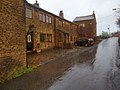
 Rochdale Road, Middleton.jpg 640 × 465; 92 KB
-
 Royal George aqueduct - geograph.org.uk - 2115.jpg 640 × 480; 63 KB
-
 Royal George Bridge, Greenfield.jpg 1,024 × 768; 151 KB
-
 Royal Oak (1), 178 Union Street, Oldham (geograph 5734459).jpg 1,024 × 683; 198 KB
-
 Ryefields.jpg 3,456 × 2,304; 1.22 MB
-
 Scowcroft Lane Bridge.jpg 800 × 600; 351 KB
-
 St Chad's Park Uppermill - geograph.org.uk - 383504.jpg 640 × 480; 119 KB
-
 Statue of John Platt.jpg 1,280 × 1,707; 1.55 MB
-
 Stocks, Uppermill.jpg 2,304 × 3,456; 4.32 MB
-
 Telephone kiosk, Dobcross.jpg 640 × 480; 70 KB
-

-
 The Observatory Alexandra Park Oldham - geograph.org.uk - 692919.jpg 480 × 640; 93 KB
-
 The Old Bell - geograph.org.uk - 681050.jpg 640 × 484; 113 KB
-
 The Old Concert Hall. - geograph.org.uk - 493734.jpg 640 × 480; 84 KB
-
 The Old County Court - geograph.org.uk - 493617.jpg 480 × 640; 98 KB
-

-
 The Square Dobcross - geograph.org.uk - 455496.jpg 640 × 480; 101 KB
-
 The Swan, Dobcross Square - geograph.org.uk - 2669811.jpg 1,280 × 960; 777 KB
-

-
 Uppermill Library - geograph.org.uk - 948649.jpg 640 × 480; 137 KB
-
 Walmsley's Warehouse, Failsworth.jpg 800 × 600; 304 KB
-
 Weaver's cottages, Delph.jpg 480 × 640; 145 KB
-
 White Lion, Delph.jpg 1,280 × 960; 488 KB
-
 Woods Lane, Dobcross.jpg 2,469 × 2,196; 3.79 MB


.jpg)


.jpg)


.jpg)


.jpg)


,_178_Union_Street,_Oldham_(geograph_5734459).jpg)


